You are here: Home > Network List > NN - Western Great Basin/Eastern Sierra Nevada Stations List
> Station GWY Greenwater Valley, CA. (GPS 12/06/2000) w84gm > Earthquake Result Viewer
GWY Greenwater Valley, CA. (GPS 12/06/2000) w84gm - Earthquake Result Viewer
| Earthquake location: |
New Ireland Region, P.N.G. |
| Earthquake latitude/longitude: |
-5.2/153.2 |
| Earthquake time(UTC): |
2015/06/27 (178) 12:24:03 GMT |
| Earthquake Depth: |
43 km |
| Earthquake Magnitude: |
5.1 MW, 5.2 mb, 4.3 MS |
| Earthquake Catalog/Contributor: |
ISC/ISC |
|
| Network: |
NN Western Great Basin/Eastern Sierra Nevada |
| Station: |
GWY Greenwater Valley, CA. (GPS 12/06/2000) w84gm |
| Lat/Lon: |
36.19 N/116.67 W |
| Elevation: |
1538 m |
|
| Distance: |
93.1 deg |
| Az: |
54.114 deg |
| Baz: |
265.874 deg |
| Ray Param: |
0.041308377 |
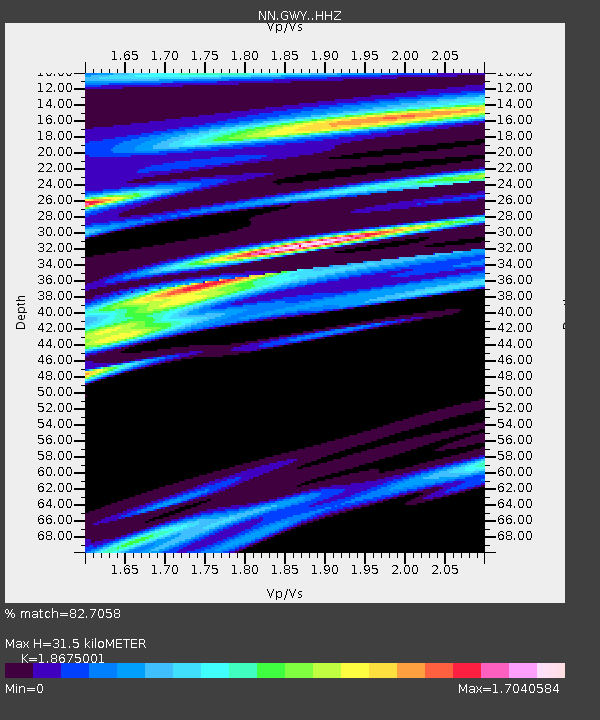
| Estimated Moho Depth: |
31.5 km |
| Estimated Crust Vp/Vs: |
1.87 |
| Assumed Crust Vp: |
6.279 km/s |
| Estimated Crust Vs: |
3.362 km/s |
| Estimated Crust Poisson's Ratio: |
0.30 |
|
| Radial Match: |
82.7058 % |
| Radial Bump: |
286 |
| Transverse Match: |
66.103325 % |
| Transverse Bump: |
320 |
| SOD ConfigId: |
7422571 |
| Insert Time: |
2019-04-19 12:30:21.249 +0000 |
| GWidth: |
2.5 |
| Max Bumps: |
400 |
| Tol: |
0.001 |
|

Signal To Noise
| Channel | StoN | STA | LTA |
| NN:GWY: :HHZ:20150627T12:36:41.627974Z | 0.91879916 | 9.825086E-8 | 1.0693399E-7 |
| NN:GWY: :HHN:20150627T12:36:41.627974Z | 1.0266353 | 7.105299E-8 | 6.920957E-8 |
| NN:GWY: :HHE:20150627T12:36:41.627974Z | 0.88697183 | 1.632448E-7 | 1.8404735E-7 |
| Arrivals |
| Ps | 4.4 SECOND |
| PpPs | 14 SECOND |
| PsPs/PpSs | 19 SECOND |


