You are here: Home > Network List > TA - USArray Transportable Network (new EarthScope stations) Stations List
> Station J01E Myrtle Point, OR, USA > Earthquake Result Viewer
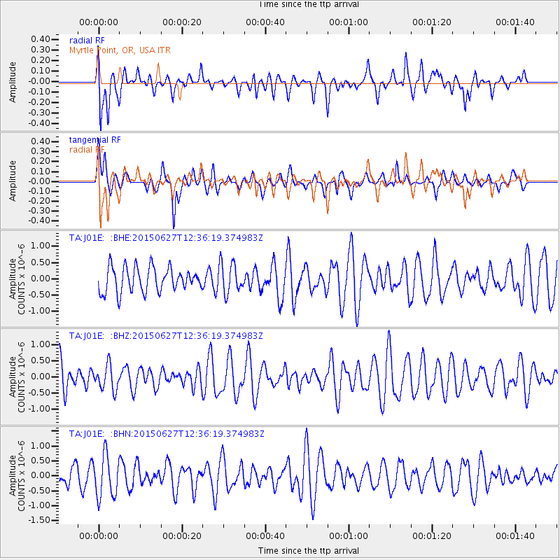
J01E Myrtle Point, OR, USA - Earthquake Result Viewer
*The percent match for this event was below the threshold and hence no stack was calculated.
| Earthquake location: |
New Ireland Region, P.N.G. |
| Earthquake latitude/longitude: |
-5.2/153.2 |
| Earthquake time(UTC): |
2015/06/27 (178) 12:24:03 GMT |
| Earthquake Depth: |
43 km |
| Earthquake Magnitude: |
5.1 MW, 5.2 mb, 4.3 MS |
| Earthquake Catalog/Contributor: |
ISC/ISC |
|
| Network: |
TA USArray Transportable Network (new EarthScope stations) |
| Station: |
J01E Myrtle Point, OR, USA |
| Lat/Lon: |
43.16 N/123.93 W |
| Elevation: |
128 m |
|
| Distance: |
88.3 deg |
| Az: |
46.579 deg |
| Baz: |
261.337 deg |
| Ray Param: |
$rayparam |
*The percent match for this event was below the threshold and hence was not used in the summary stack. |
|
| Radial Match: |
60.691006 % |
| Radial Bump: |
400 |
| Transverse Match: |
52.76371 % |
| Transverse Bump: |
400 |
| SOD ConfigId: |
7422571 |
| Insert Time: |
2019-04-19 12:31:06.771 +0000 |
| GWidth: |
2.5 |
| Max Bumps: |
400 |
| Tol: |
0.001 |
|
Signal To Noise
| Channel | StoN | STA | LTA |
| TA:J01E: :BHZ:20150627T12:36:19.374983Z | 0.6710801 | 3.9520566E-7 | 5.889098E-7 |
| TA:J01E: :BHN:20150627T12:36:19.374983Z | 2.1738434 | 7.164194E-7 | 3.2956348E-7 |
| TA:J01E: :BHE:20150627T12:36:19.374983Z | 1.2607821 | 4.7116777E-7 | 3.737107E-7 |
| Arrivals |
| Ps | |
| PpPs | |
| PsPs/PpSs | |


