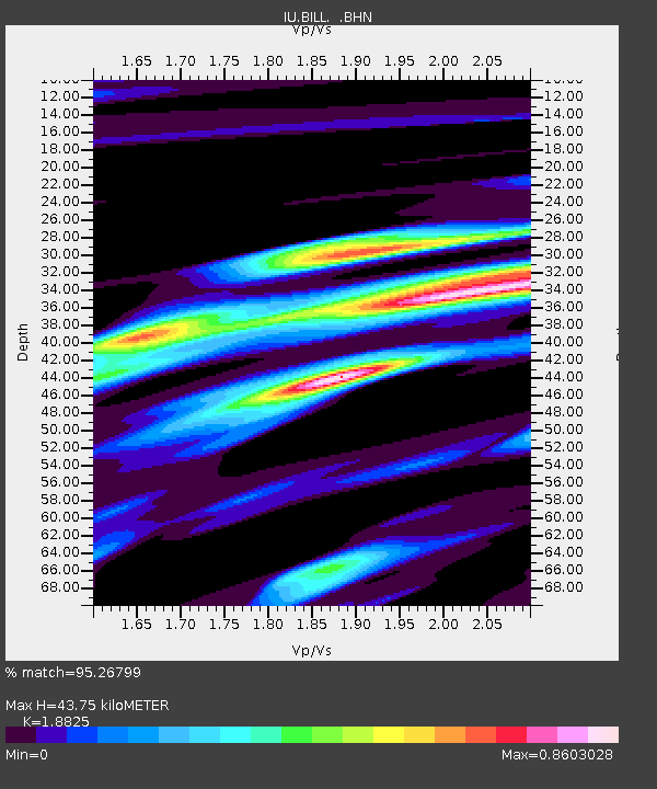
BILL Bilibino, Russia - Earthquake Result Viewer

Earthquake location: Bonin Islands, Japan Region
Earthquake latitude/longitude: 28.9/139.3
Earthquake time(UTC): 1998/08/20 (232) 06:40:55 GMT
Earthquake Depth: 441 km
Earthquake Magnitude: 6.1 MB, 7.0 UNKNOWN, 7.0 MW
Earthquake Catalog/Contributor: WHDF/NEIC
Network: IU Global Seismograph Network (GSN - IRIS/USGS)
Station: BILL Bilibino, Russia
Lat/Lon: 68.07 N/166.45 E
Elevation: 299 m
Distance: 42.3 deg
Az: 14.733 deg
Baz: 216.393 deg
Ray Param: 0.071205065
Estimated Moho Depth: 43.75 km
Estimated Crust Vp/Vs: 1.88
Assumed Crust Vp: 6.577 km/s
Estimated Crust Vs: 3.494 km/s
Estimated Crust Poisson's Ratio: 0.30
Radial Match: 95.26799 %
Radial Bump: 400
Transverse Match: 93.22919 %
Transverse Bump: 400
SOD ConfigId: 4480
Insert Time: 2010-03-03 15:19:43.211 +0000
GWidth: 2.5
Max Bumps: 400
Tol: 0.001

Signal To Noise

ChannelStoNSTALTA
IU:BILL: :BHN:19980820T06:47:38.862012Z15.421283.009908E-61.9517886E-7
IU:BILL: :BHE:19980820T06:47:38.862012Z2.25233981.2625121E-65.605336E-7
IU:BILL: :BHZ:19980820T06:47:38.862012Z2.71517047.44129E-72.7406347E-7
Arrivals
Ps6.3 SECOND
PpPs18 SECOND
PsPs/PpSs24 SECOND