You are here: Home > Network List > IU - Global Seismograph Network (GSN - IRIS/USGS) Stations List
> Station BILL Bilibino, Russia > Earthquake Result Viewer
BILL Bilibino, Russia - Earthquake Result Viewer
| Earthquake location: |
Mariana Islands Region |
| Earthquake latitude/longitude: |
17.1/148.1 |
| Earthquake time(UTC): |
1998/08/30 (242) 01:48:08 GMT |
| Earthquake Depth: |
33 km |
| Earthquake Magnitude: |
6.0 MB, 6.1 MS, 6.2 UNKNOWN, 5.9 ME |
| Earthquake Catalog/Contributor: |
WHDF/NEIC |
|
| Network: |
IU Global Seismograph Network (GSN - IRIS/USGS) |
| Station: |
BILL Bilibino, Russia |
| Lat/Lon: |
68.07 N/166.45 E |
| Elevation: |
299 m |
|
| Distance: |
52.3 deg |
| Az: |
8.586 deg |
| Baz: |
202.336 deg |
| Ray Param: |
0.06680083 |
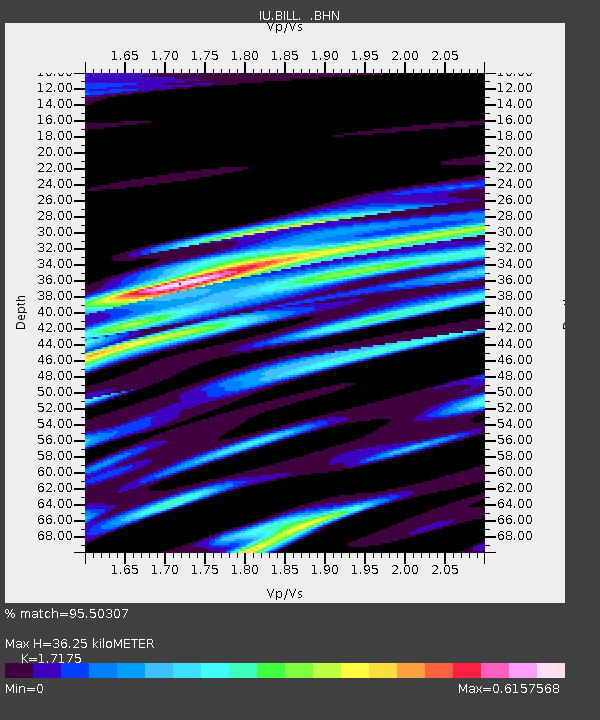
| Estimated Moho Depth: |
36.25 km |
| Estimated Crust Vp/Vs: |
1.72 |
| Assumed Crust Vp: |
6.577 km/s |
| Estimated Crust Vs: |
3.829 km/s |
| Estimated Crust Poisson's Ratio: |
0.24 |
|
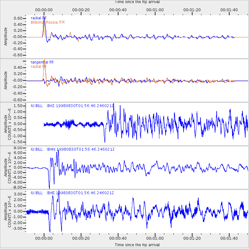
| Radial Match: |
95.50307 % |
| Radial Bump: |
400 |
| Transverse Match: |
89.80049 % |
| Transverse Bump: |
400 |
| SOD ConfigId: |
4480 |
| Insert Time: |
2010-03-03 15:19:49.603 +0000 |
| GWidth: |
2.5 |
| Max Bumps: |
400 |
| Tol: |
0.001 |
|
Signal To Noise
| Channel | StoN | STA | LTA |
| IU:BILL: :BHN:19980830T01:56:46.246021Z | 29.93426 | 2.8630466E-6 | 9.5644474E-8 |
| IU:BILL: :BHE:19980830T01:56:46.246021Z | 6.1843867 | 1.3634257E-6 | 2.2046254E-7 |
| IU:BILL: :BHZ:19980830T01:56:46.246021Z | 3.960564 | 5.3478647E-7 | 1.3502786E-7 |
| Arrivals |
| Ps | 4.2 SECOND |
| PpPs | 14 SECOND |
| PsPs/PpSs | 18 SECOND |


