You are here: Home > Network List > AV - Alaska Volcano Observatory Stations List
> Station MAPS Pakushin Southeast, Makushin Volcano, Alaska > Earthquake Result Viewer
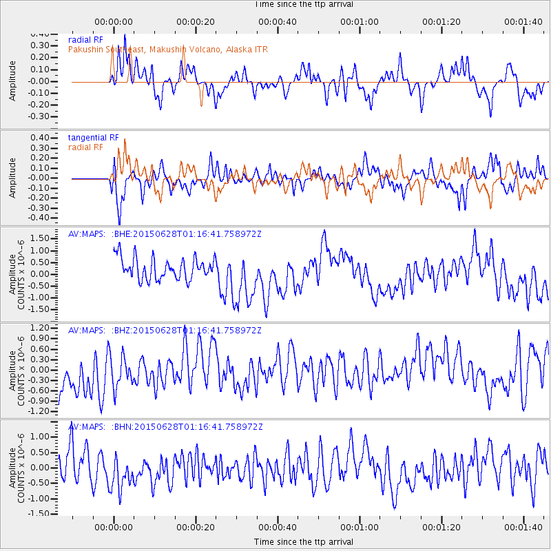
MAPS Pakushin Southeast, Makushin Volcano, Alaska - Earthquake Result Viewer
*The percent match for this event was below the threshold and hence no stack was calculated.
| Earthquake location: |
Northeastern India |
| Earthquake latitude/longitude: |
26.7/90.4 |
| Earthquake time(UTC): |
2015/06/28 (179) 01:05:26 GMT |
| Earthquake Depth: |
10 km |
| Earthquake Magnitude: |
5.6 MB |
| Earthquake Catalog/Contributor: |
NEIC PDE/NEIC ALERT |
|
| Network: |
AV Alaska Volcano Observatory |
| Station: |
MAPS Pakushin Southeast, Makushin Volcano, Alaska |
| Lat/Lon: |
53.81 N/166.94 W |
| Elevation: |
333 m |
|
| Distance: |
75.9 deg |
| Az: |
36.623 deg |
| Baz: |
295.847 deg |
| Ray Param: |
$rayparam |
*The percent match for this event was below the threshold and hence was not used in the summary stack. |
|
| Radial Match: |
58.005882 % |
| Radial Bump: |
400 |
| Transverse Match: |
57.163567 % |
| Transverse Bump: |
400 |
| SOD ConfigId: |
7422571 |
| Insert Time: |
2019-04-19 12:40:30.509 +0000 |
| GWidth: |
2.5 |
| Max Bumps: |
400 |
| Tol: |
0.001 |
|
Signal To Noise
| Channel | StoN | STA | LTA |
| AV:MAPS: :BHZ:20150628T01:16:41.758972Z | 0.71248525 | 4.850347E-7 | 6.807645E-7 |
| AV:MAPS: :BHN:20150628T01:16:41.758972Z | 1.2921159 | 6.032219E-7 | 4.6684812E-7 |
| AV:MAPS: :BHE:20150628T01:16:41.758972Z | 2.6358237 | 1.1786543E-6 | 4.471673E-7 |
| Arrivals |
| Ps | |
| PpPs | |
| PsPs/PpSs | |


