You are here: Home > Network List > IU - Global Seismograph Network (GSN - IRIS/USGS) Stations List
> Station BILL Bilibino, Russia > Earthquake Result Viewer
BILL Bilibino, Russia - Earthquake Result Viewer
| Earthquake location: |
Ceram Sea |
| Earthquake latitude/longitude: |
-2.1/124.9 |
| Earthquake time(UTC): |
1998/11/29 (333) 14:10:31 GMT |
| Earthquake Depth: |
33 km |
| Earthquake Magnitude: |
6.5 MB, 7.7 MS, 8.1 UNKNOWN, 7.8 MW |
| Earthquake Catalog/Contributor: |
WHDF/NEIC |
|
| Network: |
IU Global Seismograph Network (GSN - IRIS/USGS) |
| Station: |
BILL Bilibino, Russia |
| Lat/Lon: |
68.07 N/166.45 E |
| Elevation: |
299 m |
|
| Distance: |
75.7 deg |
| Az: |
14.908 deg |
| Baz: |
223.182 deg |
| Ray Param: |
0.051471878 |
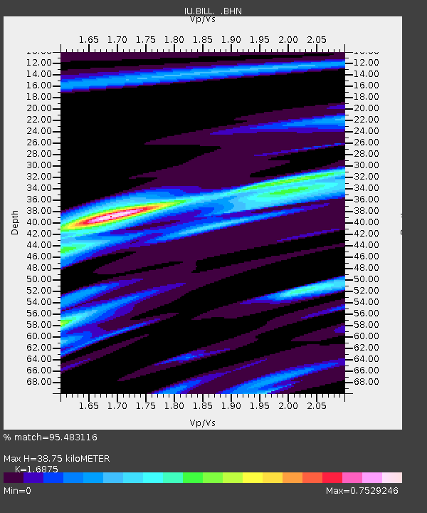
| Estimated Moho Depth: |
38.75 km |
| Estimated Crust Vp/Vs: |
1.69 |
| Assumed Crust Vp: |
6.577 km/s |
| Estimated Crust Vs: |
3.897 km/s |
| Estimated Crust Poisson's Ratio: |
0.23 |
|
| Radial Match: |
95.483116 % |
| Radial Bump: |
351 |
| Transverse Match: |
82.384674 % |
| Transverse Bump: |
400 |
| SOD ConfigId: |
4480 |
| Insert Time: |
2010-03-03 15:20:14.308 +0000 |
| GWidth: |
2.5 |
| Max Bumps: |
400 |
| Tol: |
0.001 |
|
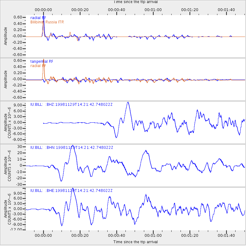
Signal To Noise
| Channel | StoN | STA | LTA |
| IU:BILL: :BHN:19981129T14:21:42.748022Z | 5.357387 | 1.0908991E-6 | 2.036252E-7 |
| IU:BILL: :BHE:19981129T14:21:42.748022Z | 1.8234452 | 4.116102E-7 | 2.2573214E-7 |
| IU:BILL: :BHZ:19981129T14:21:42.748022Z | 2.807966 | 4.4901105E-7 | 1.5990616E-7 |
| Arrivals |
| Ps | 4.2 SECOND |
| PpPs | 15 SECOND |
| PsPs/PpSs | 19 SECOND |


