You are here: Home > Network List > AV - Alaska Volcano Observatory Stations List
> Station MAPS Pakushin Southeast, Makushin Volcano, Alaska > Earthquake Result Viewer
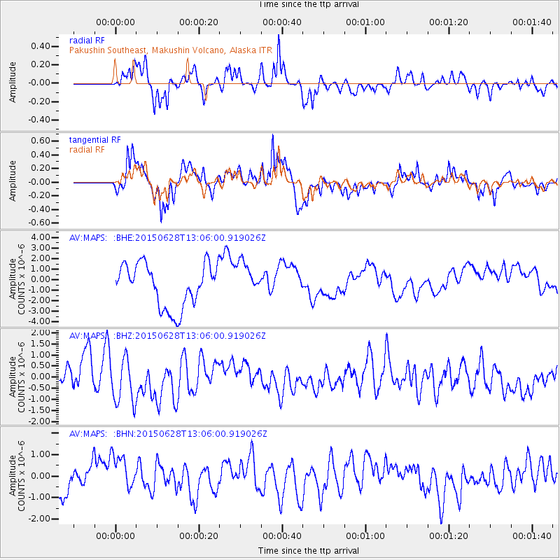
MAPS Pakushin Southeast, Makushin Volcano, Alaska - Earthquake Result Viewer
*The percent match for this event was below the threshold and hence no stack was calculated.
| Earthquake location: |
South Of Kermadec Islands |
| Earthquake latitude/longitude: |
-32.2/-178.3 |
| Earthquake time(UTC): |
2015/06/28 (179) 12:53:50 GMT |
| Earthquake Depth: |
10 km |
| Earthquake Magnitude: |
5.1 MW, 5.1 mb, 4.8 MS |
| Earthquake Catalog/Contributor: |
ISC/ISC |
|
| Network: |
AV Alaska Volcano Observatory |
| Station: |
MAPS Pakushin Southeast, Makushin Volcano, Alaska |
| Lat/Lon: |
53.81 N/166.94 W |
| Elevation: |
333 m |
|
| Distance: |
86.2 deg |
| Az: |
6.726 deg |
| Baz: |
189.634 deg |
| Ray Param: |
$rayparam |
*The percent match for this event was below the threshold and hence was not used in the summary stack. |
|
| Radial Match: |
75.21381 % |
| Radial Bump: |
400 |
| Transverse Match: |
68.531586 % |
| Transverse Bump: |
400 |
| SOD ConfigId: |
7422571 |
| Insert Time: |
2019-04-19 12:43:40.403 +0000 |
| GWidth: |
2.5 |
| Max Bumps: |
400 |
| Tol: |
0.001 |
|
Signal To Noise
| Channel | StoN | STA | LTA |
| AV:MAPS: :BHZ:20150628T13:06:00.919026Z | 1.5792223 | 1.1359243E-6 | 7.192935E-7 |
| AV:MAPS: :BHN:20150628T13:06:00.919026Z | 1.1750332 | 8.164169E-7 | 6.948033E-7 |
| AV:MAPS: :BHE:20150628T13:06:00.919026Z | 0.8123983 | 1.6625597E-6 | 2.0464834E-6 |
| Arrivals |
| Ps | |
| PpPs | |
| PsPs/PpSs | |


