You are here: Home > Network List > IU - Global Seismograph Network (GSN - IRIS/USGS) Stations List
> Station BILL Bilibino, Russia > Earthquake Result Viewer
BILL Bilibino, Russia - Earthquake Result Viewer
| Earthquake location: |
Pakistan |
| Earthquake latitude/longitude: |
30.0/68.2 |
| Earthquake time(UTC): |
1997/02/27 (058) 21:08:02 GMT |
| Earthquake Depth: |
33 km |
| Earthquake Magnitude: |
6.3 MB, 7.3 MS, 7.1 UNKNOWN, 6.6 ME |
| Earthquake Catalog/Contributor: |
WHDF/NEIC |
|
| Network: |
IU Global Seismograph Network (GSN - IRIS/USGS) |
| Station: |
BILL Bilibino, Russia |
| Lat/Lon: |
68.07 N/166.45 E |
| Elevation: |
299 m |
|
| Distance: |
65.5 deg |
| Az: |
24.109 deg |
| Baz: |
289.381 deg |
| Ray Param: |
0.05814762 |
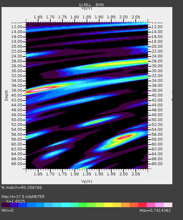
| Estimated Moho Depth: |
37.5 km |
| Estimated Crust Vp/Vs: |
1.65 |
| Assumed Crust Vp: |
6.577 km/s |
| Estimated Crust Vs: |
3.98 km/s |
| Estimated Crust Poisson's Ratio: |
0.21 |
|
| Radial Match: |
95.286766 % |
| Radial Bump: |
400 |
| Transverse Match: |
88.942116 % |
| Transverse Bump: |
400 |
| SOD ConfigId: |
4480 |
| Insert Time: |
2010-03-03 15:20:21.401 +0000 |
| GWidth: |
2.5 |
| Max Bumps: |
400 |
| Tol: |
0.001 |
|
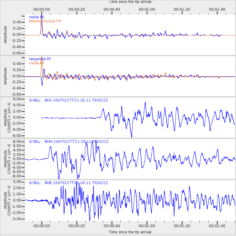
Signal To Noise
| Channel | StoN | STA | LTA |
| IU:BILL: :BHN:19970227T21:18:11.760022Z | 19.473574 | 1.8278852E-6 | 9.3864905E-8 |
| IU:BILL: :BHE:19970227T21:18:11.760022Z | 1.0487175 | 2.2318801E-7 | 2.1281997E-7 |
| IU:BILL: :BHZ:19970227T21:18:11.760022Z | 18.140205 | 8.2573644E-7 | 4.5519684E-8 |
| Arrivals |
| Ps | 3.9 SECOND |
| PpPs | 14 SECOND |
| PsPs/PpSs | 18 SECOND |


