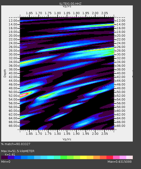
TEIG Tepich, Yucatan, Mexico - Earthquake Result Viewer
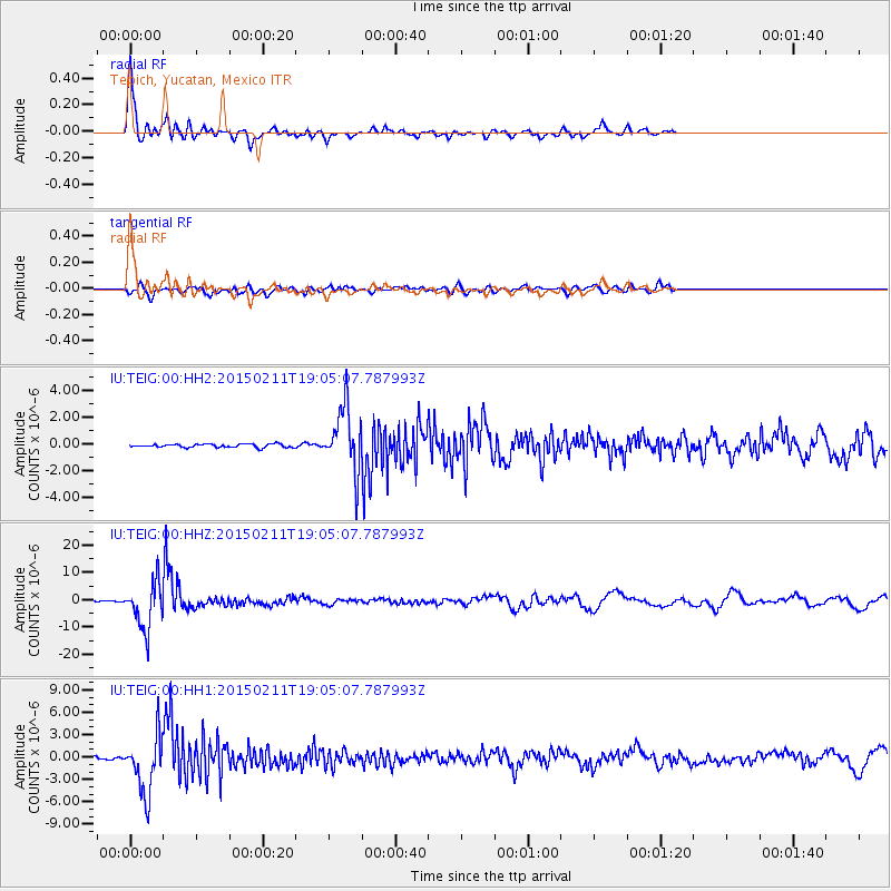
Earthquake location: Jujuy Province, Argentina
Earthquake latitude/longitude: -23.1/-66.7
Earthquake time(UTC): 2015/02/11 (042) 18:57:22 GMT
Earthquake Depth: 223 km
Earthquake Magnitude: 6.7 MWW, 6.7 MWC, 6.7 MWB, 6.9 MI
Earthquake Catalog/Contributor: NEIC PDE/NEIC COMCAT
Network: IU Global Seismograph Network (GSN - IRIS/USGS)
Station: TEIG Tepich, Yucatan, Mexico
Lat/Lon: 20.23 N/88.28 W
Elevation: 40 m
Distance: 47.9 deg
Az: 332.27 deg
Baz: 152.857 deg
Ray Param: 0.068819866
Estimated Moho Depth: 51.5 km
Estimated Crust Vp/Vs: 1.61
Assumed Crust Vp: 5.817 km/s
Estimated Crust Vs: 3.613 km/s
Estimated Crust Poisson's Ratio: 0.19
Radial Match: 90.83327 %
Radial Bump: 400
Transverse Match: 64.22747 %
Transverse Bump: 400
SOD ConfigId: 872571
Insert Time: 2015-02-25 19:03:46.422 +0000
GWidth: 2.5
Max Bumps: 400
Tol: 0.001

Signal To Noise

ChannelStoNSTALTA
IU:TEIG:00:HHZ:20150211T19:05:07.787993Z42.7912568.4639205E-61.9779556E-7
IU:TEIG:00:HH1:20150211T19:05:07.787993Z32.639023.87573E-61.18745305E-7
IU:TEIG:00:HH2:20150211T19:05:07.787993Z18.1035422.305685E-61.2736098E-7
Arrivals
Ps5.7 SECOND
PpPs22 SECOND
PsPs/PpSs28 SECOND