You are here: Home > Network List > TA - USArray Transportable Network (new EarthScope stations) Stations List
> Station MSTX Muleshoe, TX, USA > Earthquake Result Viewer
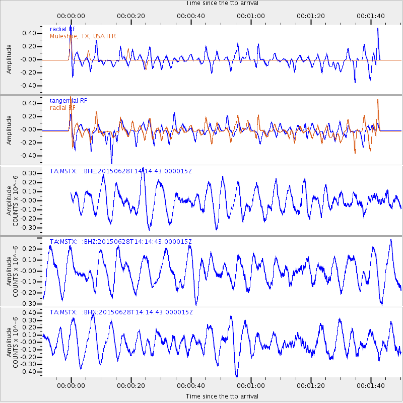
MSTX Muleshoe, TX, USA - Earthquake Result Viewer
*The percent match for this event was below the threshold and hence no stack was calculated.
| Earthquake location: |
Hokkaido, Japan Region |
| Earthquake latitude/longitude: |
42.7/139.1 |
| Earthquake time(UTC): |
2015/06/28 (179) 14:03:04 GMT |
| Earthquake Depth: |
226 km |
| Earthquake Magnitude: |
4.1 mb, 4.1 mb |
| Earthquake Catalog/Contributor: |
ISC/ISC |
|
| Network: |
TA USArray Transportable Network (new EarthScope stations) |
| Station: |
MSTX Muleshoe, TX, USA |
| Lat/Lon: |
33.97 N/102.77 W |
| Elevation: |
1167 m |
|
| Distance: |
85.0 deg |
| Az: |
47.361 deg |
| Baz: |
319.272 deg |
| Ray Param: |
$rayparam |
*The percent match for this event was below the threshold and hence was not used in the summary stack. |
|
| Radial Match: |
52.467693 % |
| Radial Bump: |
400 |
| Transverse Match: |
70.37487 % |
| Transverse Bump: |
400 |
| SOD ConfigId: |
7422571 |
| Insert Time: |
2019-04-19 12:53:31.414 +0000 |
| GWidth: |
2.5 |
| Max Bumps: |
400 |
| Tol: |
0.001 |
|
Signal To Noise
| Channel | StoN | STA | LTA |
| TA:MSTX: :BHZ:20150628T14:14:43.000015Z | 0.8041252 | 1.03184696E-7 | 1.2831919E-7 |
| TA:MSTX: :BHN:20150628T14:14:43.000015Z | 2.4060826 | 2.3354482E-7 | 9.706434E-8 |
| TA:MSTX: :BHE:20150628T14:14:43.000015Z | 1.2777351 | 1.6996631E-7 | 1.3302156E-7 |
| Arrivals |
| Ps | |
| PpPs | |
| PsPs/PpSs | |


