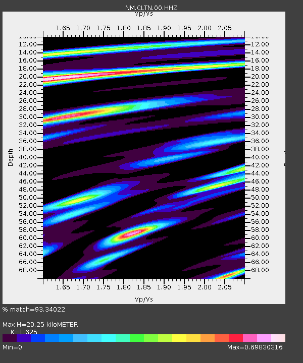
CLTN Cedars of Lebanon,TN - Earthquake Result Viewer

Earthquake location: Jujuy Province, Argentina
Earthquake latitude/longitude: -23.1/-66.7
Earthquake time(UTC): 2015/02/11 (042) 18:57:22 GMT
Earthquake Depth: 223 km
Earthquake Magnitude: 6.7 MWW, 6.7 MWC, 6.7 MWB, 6.9 MI
Earthquake Catalog/Contributor: NEIC PDE/NEIC COMCAT
Network: NM Cooperative New Madrid Seismic Network
Station: CLTN Cedars of Lebanon,TN
Lat/Lon: 36.09 N/86.33 W
Elevation: 208 m
Distance: 61.7 deg
Az: 341.996 deg
Baz: 159.43 deg
Ray Param: 0.05997739
Estimated Moho Depth: 20.25 km
Estimated Crust Vp/Vs: 1.62
Assumed Crust Vp: 6.444 km/s
Estimated Crust Vs: 3.965 km/s
Estimated Crust Poisson's Ratio: 0.20
Radial Match: 93.34022 %
Radial Bump: 368
Transverse Match: 76.16999 %
Transverse Bump: 400
SOD ConfigId: 872571
Insert Time: 2015-02-25 19:05:12.180 +0000
GWidth: 2.5
Max Bumps: 400
Tol: 0.001

Signal To Noise

ChannelStoNSTALTA
NM:CLTN:00:HHZ:20150211T19:06:46.314971Z19.1184965.00451E-62.6176272E-7
NM:CLTN:00:HHN:20150211T19:06:46.314971Z6.4568592.151062E-63.3314373E-7
NM:CLTN:00:HHE:20150211T19:06:46.314971Z5.01925851.0721928E-62.1361579E-7
Arrivals
Ps2.1 SECOND
PpPs7.9 SECOND
PsPs/PpSs9.9 SECOND