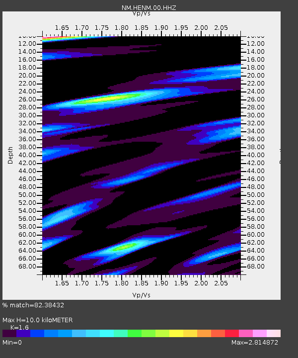
HENM Henderson Mound,MO - Earthquake Result Viewer

Earthquake location: Jujuy Province, Argentina
Earthquake latitude/longitude: -23.1/-66.7
Earthquake time(UTC): 2015/02/11 (042) 18:57:22 GMT
Earthquake Depth: 223 km
Earthquake Magnitude: 6.7 MWW, 6.7 MWC, 6.7 MWB, 6.9 MI
Earthquake Catalog/Contributor: NEIC PDE/NEIC COMCAT
Network: NM Cooperative New Madrid Seismic Network
Station: HENM Henderson Mound,MO
Lat/Lon: 36.72 N/89.47 W
Elevation: 88 m
Distance: 63.3 deg
Az: 339.612 deg
Baz: 156.473 deg
Ray Param: 0.058993857
Estimated Moho Depth: 10.0 km
Estimated Crust Vp/Vs: 1.60
Assumed Crust Vp: 6.444 km/s
Estimated Crust Vs: 4.027 km/s
Estimated Crust Poisson's Ratio: 0.18
Radial Match: 82.38432 %
Radial Bump: 400
Transverse Match: 72.21201 %
Transverse Bump: 400
SOD ConfigId: 872571
Insert Time: 2015-02-25 19:05:36.173 +0000
GWidth: 2.5
Max Bumps: 400
Tol: 0.001

Signal To Noise

ChannelStoNSTALTA
NM:HENM:00:HHZ:20150211T19:06:56.389983Z14.5527557.916159E-65.4396287E-7
NM:HENM:00:HHN:20150211T19:06:56.389983Z5.2427354.3650953E-68.3259886E-7
NM:HENM:00:HHE:20150211T19:06:56.389983Z5.58380273.6938648E-66.615321E-7
Arrivals
Ps1.0 SECOND
PpPs3.8 SECOND
PsPs/PpSs4.8 SECOND