You are here: Home > Network List > CI - Caltech Regional Seismic Network Stations List
> Station SWS Sam W. Stewart, Westmorland, CA, USA > Earthquake Result Viewer
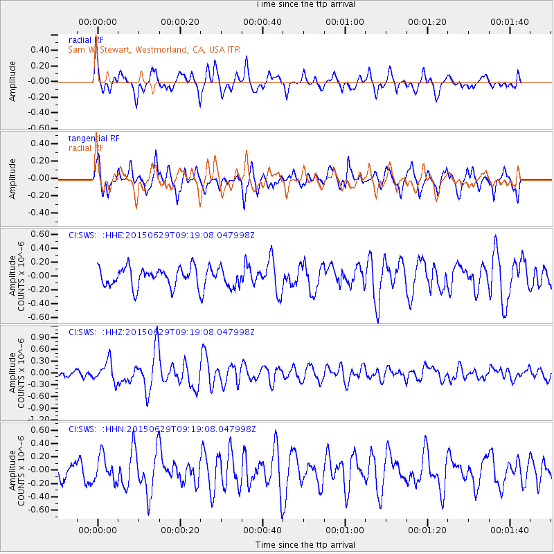
SWS Sam W. Stewart, Westmorland, CA, USA - Earthquake Result Viewer
*The percent match for this event was below the threshold and hence no stack was calculated.
| Earthquake location: |
Near Coast Of Peru |
| Earthquake latitude/longitude: |
-16.0/-74.2 |
| Earthquake time(UTC): |
2015/06/29 (180) 09:09:15 GMT |
| Earthquake Depth: |
24 km |
| Earthquake Magnitude: |
5.5 MB |
| Earthquake Catalog/Contributor: |
NEIC PDE/NEIC ALERT |
|
| Network: |
CI Caltech Regional Seismic Network |
| Station: |
SWS Sam W. Stewart, Westmorland, CA, USA |
| Lat/Lon: |
32.94 N/115.80 W |
| Elevation: |
140 m |
|
| Distance: |
62.8 deg |
| Az: |
321.149 deg |
| Baz: |
134.16 deg |
| Ray Param: |
$rayparam |
*The percent match for this event was below the threshold and hence was not used in the summary stack. |
|
| Radial Match: |
73.284615 % |
| Radial Bump: |
400 |
| Transverse Match: |
61.71005 % |
| Transverse Bump: |
400 |
| SOD ConfigId: |
7422571 |
| Insert Time: |
2019-04-19 13:01:58.316 +0000 |
| GWidth: |
2.5 |
| Max Bumps: |
400 |
| Tol: |
0.001 |
|
Signal To Noise
| Channel | StoN | STA | LTA |
| CI:SWS: :HHZ:20150629T09:19:08.047998Z | 2.8095787 | 2.7455224E-7 | 9.772007E-8 |
| CI:SWS: :HHN:20150629T09:19:08.047998Z | 0.91630495 | 1.9250828E-7 | 2.1009194E-7 |
| CI:SWS: :HHE:20150629T09:19:08.047998Z | 0.94447815 | 1.3180899E-7 | 1.3955747E-7 |
| Arrivals |
| Ps | |
| PpPs | |
| PsPs/PpSs | |


