BILL Bilibino, Russia - Earthquake Result Viewer
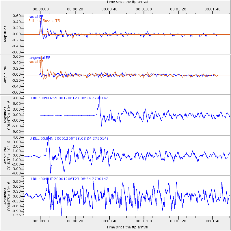
Earthquake location: New Britain Region, P.N.G.
Earthquake latitude/longitude: -4.2/152.7
Earthquake time(UTC): 2000/12/06 (341) 22:57:40 GMT
Earthquake Depth: 31 km
Earthquake Magnitude: 6.1 MB, 6.6 MS, 6.6 MW, 6.2 ME
Earthquake Catalog/Contributor: WHDF/NEIC
Network: IU Global Seismograph Network (GSN - IRIS/USGS)
Station: BILL Bilibino, Russia
Lat/Lon: 68.07 N/166.45 E
Elevation: 299 m
Distance: 72.8 deg
Az: 5.356 deg
Baz: 194.347 deg
Ray Param: 0.05340253
Estimated Moho Depth: 27.0 km
Estimated Crust Vp/Vs: 1.97
Assumed Crust Vp: 6.577 km/s
Estimated Crust Vs: 3.343 km/s
Estimated Crust Poisson's Ratio: 0.33
Radial Match: 96.23005 %
Radial Bump: 400
Transverse Match: 73.05984 %
Transverse Bump: 400
SOD ConfigId: 3744
Insert Time: 2010-03-03 15:22:07.459 +0000
GWidth: 2.5
Max Bumps: 400
Tol: 0.001

Signal To Noise

ChannelStoNSTALTA
IU:BILL:00:BHN:20001206T23:08:34.279014Z12.1618511.6045818E-61.3193566E-7
IU:BILL:00:BHE:20001206T23:08:34.279014Z2.9907674.3926238E-71.4687282E-7
IU:BILL:00:BHZ:20001206T23:08:34.279014Z33.5130543.4133743E-61.0185208E-7
Arrivals
Ps4.1 SECOND
PpPs12 SECOND
PsPs/PpSs16 SECOND