You are here: Home > Network List > IU - Global Seismograph Network (GSN - IRIS/USGS) Stations List
> Station BILL Bilibino, Russia > Earthquake Result Viewer
BILL Bilibino, Russia - Earthquake Result Viewer
| Earthquake location: |
Western Honshu, Japan |
| Earthquake latitude/longitude: |
35.5/133.1 |
| Earthquake time(UTC): |
2000/10/06 (280) 04:30:19 GMT |
| Earthquake Depth: |
10 km |
| Earthquake Magnitude: |
5.8 MB, 6.8 MS, 7.0 ME, 6.7 MW |
| Earthquake Catalog/Contributor: |
WHDF/NEIC |
|
| Network: |
IU Global Seismograph Network (GSN - IRIS/USGS) |
| Station: |
BILL Bilibino, Russia |
| Lat/Lon: |
68.07 N/166.45 E |
| Elevation: |
299 m |
|
| Distance: |
37.7 deg |
| Az: |
19.735 deg |
| Baz: |
227.201 deg |
| Ray Param: |
0.07600438 |
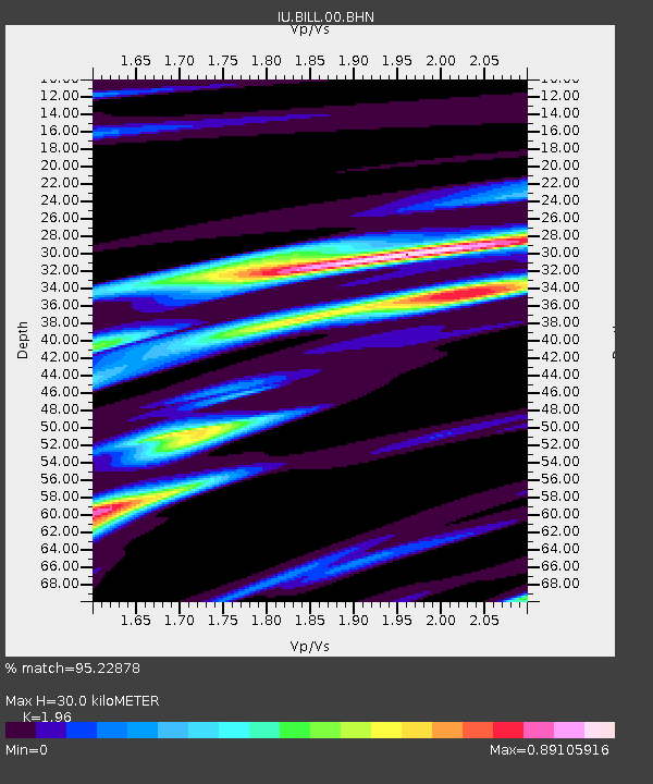
| Estimated Moho Depth: |
30.0 km |
| Estimated Crust Vp/Vs: |
1.96 |
| Assumed Crust Vp: |
6.577 km/s |
| Estimated Crust Vs: |
3.355 km/s |
| Estimated Crust Poisson's Ratio: |
0.32 |
|
| Radial Match: |
95.22878 % |
| Radial Bump: |
373 |
| Transverse Match: |
91.72666 % |
| Transverse Bump: |
400 |
| SOD ConfigId: |
3744 |
| Insert Time: |
2010-03-03 15:22:13.528 +0000 |
| GWidth: |
2.5 |
| Max Bumps: |
400 |
| Tol: |
0.001 |
|

Signal To Noise
| Channel | StoN | STA | LTA |
| IU:BILL:00:BHN:20001006T04:37:03.681006Z | 6.1275463 | 9.199452E-7 | 1.5013272E-7 |
| IU:BILL:00:BHE:20001006T04:37:03.681006Z | 7.0064435 | 8.5364957E-7 | 1.2183779E-7 |
| IU:BILL:00:BHZ:20001006T04:37:03.681006Z | 17.64496 | 1.840903E-6 | 1.0433024E-7 |
| Arrivals |
| Ps | 4.7 SECOND |
| PpPs | 13 SECOND |
| PsPs/PpSs | 17 SECOND |


