You are here: Home > Network List > US - United States National Seismic Network Stations List
> Station DGMT Dagmar, Montana, USA > Earthquake Result Viewer
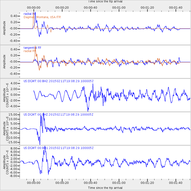
DGMT Dagmar, Montana, USA - Earthquake Result Viewer
*The percent match for this event was below the threshold and hence no stack was calculated.
| Earthquake location: |
Jujuy Province, Argentina |
| Earthquake latitude/longitude: |
-23.1/-66.7 |
| Earthquake time(UTC): |
2015/02/11 (042) 18:57:22 GMT |
| Earthquake Depth: |
223 km |
| Earthquake Magnitude: |
6.7 MWW, 6.7 MWC, 6.7 MWB, 6.9 MI |
| Earthquake Catalog/Contributor: |
NEIC PDE/NEIC COMCAT |
|
| Network: |
US United States National Seismic Network |
| Station: |
DGMT Dagmar, Montana, USA |
| Lat/Lon: |
48.47 N/104.20 W |
| Elevation: |
0.0 m |
|
| Distance: |
78.8 deg |
| Az: |
335.601 deg |
| Baz: |
145.145 deg |
| Ray Param: |
$rayparam |
*The percent match for this event was below the threshold and hence was not used in the summary stack. |
|
| Radial Match: |
85.19549 % |
| Radial Bump: |
356 |
| Transverse Match: |
65.56768 % |
| Transverse Bump: |
400 |
| SOD ConfigId: |
872571 |
| Insert Time: |
2015-02-25 19:06:57.346 +0000 |
| GWidth: |
2.5 |
| Max Bumps: |
400 |
| Tol: |
0.001 |
|
Signal To Noise
| Channel | StoN | STA | LTA |
| US:DGMT:00:BHZ:20150211T19:08:29.100005Z | 16.725946 | 6.7485057E-6 | 4.0347527E-7 |
| US:DGMT:00:BH1:20150211T19:08:29.100005Z | 2.2120974 | 2.2933023E-6 | 1.0367095E-6 |
| US:DGMT:00:BH2:20150211T19:08:29.100005Z | 1.2857244 | 1.2218499E-6 | 9.5032016E-7 |
| Arrivals |
| Ps | |
| PpPs | |
| PsPs/PpSs | |


