You are here: Home > Network List > TA - USArray Transportable Network (new EarthScope stations) Stations List
> Station 435B Jarrell, TX, USA > Earthquake Result Viewer
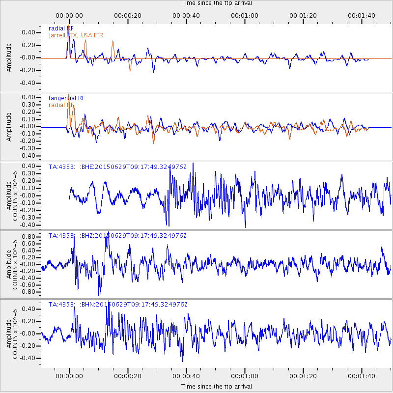
435B Jarrell, TX, USA - Earthquake Result Viewer
*The percent match for this event was below the threshold and hence no stack was calculated.
| Earthquake location: |
Near Coast Of Peru |
| Earthquake latitude/longitude: |
-16.0/-74.2 |
| Earthquake time(UTC): |
2015/06/29 (180) 09:09:15 GMT |
| Earthquake Depth: |
24 km |
| Earthquake Magnitude: |
5.5 MB |
| Earthquake Catalog/Contributor: |
NEIC PDE/NEIC ALERT |
|
| Network: |
TA USArray Transportable Network (new EarthScope stations) |
| Station: |
435B Jarrell, TX, USA |
| Lat/Lon: |
30.78 N/97.58 W |
| Elevation: |
248 m |
|
| Distance: |
51.7 deg |
| Az: |
334.201 deg |
| Baz: |
150.901 deg |
| Ray Param: |
$rayparam |
*The percent match for this event was below the threshold and hence was not used in the summary stack. |
|
| Radial Match: |
60.119297 % |
| Radial Bump: |
400 |
| Transverse Match: |
69.31248 % |
| Transverse Bump: |
400 |
| SOD ConfigId: |
7422571 |
| Insert Time: |
2019-04-19 13:06:53.817 +0000 |
| GWidth: |
2.5 |
| Max Bumps: |
400 |
| Tol: |
0.001 |
|
Signal To Noise
| Channel | StoN | STA | LTA |
| TA:435B: :BHZ:20150629T09:17:49.324976Z | 4.462737 | 3.095454E-7 | 6.936224E-8 |
| TA:435B: :BHN:20150629T09:17:49.324976Z | 2.2659717 | 1.4904128E-7 | 6.5773676E-8 |
| TA:435B: :BHE:20150629T09:17:49.324976Z | 1.7243214 | 1.6308856E-7 | 9.45813E-8 |
| Arrivals |
| Ps | |
| PpPs | |
| PsPs/PpSs | |


