You are here: Home > Network List > TA - USArray Transportable Network (new EarthScope stations) Stations List
> Station A04D Lummi Island, WA, USA > Earthquake Result Viewer
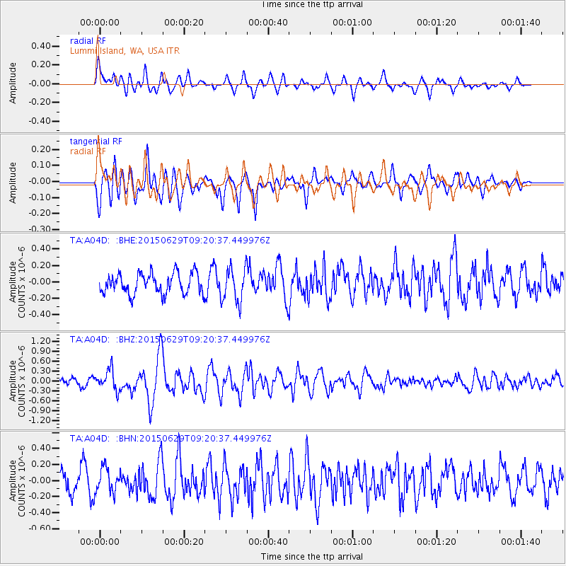
A04D Lummi Island, WA, USA - Earthquake Result Viewer
*The percent match for this event was below the threshold and hence no stack was calculated.
| Earthquake location: |
Near Coast Of Peru |
| Earthquake latitude/longitude: |
-16.0/-74.2 |
| Earthquake time(UTC): |
2015/06/29 (180) 09:09:15 GMT |
| Earthquake Depth: |
24 km |
| Earthquake Magnitude: |
5.5 MB |
| Earthquake Catalog/Contributor: |
NEIC PDE/NEIC ALERT |
|
| Network: |
TA USArray Transportable Network (new EarthScope stations) |
| Station: |
A04D Lummi Island, WA, USA |
| Lat/Lon: |
48.72 N/122.71 W |
| Elevation: |
13 m |
|
| Distance: |
77.5 deg |
| Az: |
329.469 deg |
| Baz: |
132.463 deg |
| Ray Param: |
$rayparam |
*The percent match for this event was below the threshold and hence was not used in the summary stack. |
|
| Radial Match: |
63.62905 % |
| Radial Bump: |
400 |
| Transverse Match: |
67.289604 % |
| Transverse Bump: |
400 |
| SOD ConfigId: |
7422571 |
| Insert Time: |
2019-04-19 13:06:54.383 +0000 |
| GWidth: |
2.5 |
| Max Bumps: |
400 |
| Tol: |
0.001 |
|
Signal To Noise
| Channel | StoN | STA | LTA |
| TA:A04D: :BHZ:20150629T09:20:37.449976Z | 1.9602937 | 3.154253E-7 | 1.6090716E-7 |
| TA:A04D: :BHN:20150629T09:20:37.449976Z | 1.0201459 | 1.5142452E-7 | 1.484342E-7 |
| TA:A04D: :BHE:20150629T09:20:37.449976Z | 1.6564106 | 2.0829621E-7 | 1.2575155E-7 |
| Arrivals |
| Ps | |
| PpPs | |
| PsPs/PpSs | |


