You are here: Home > Network List > TA - USArray Transportable Network (new EarthScope stations) Stations List
> Station TPFO Pinon Flats, CA, USA > Earthquake Result Viewer
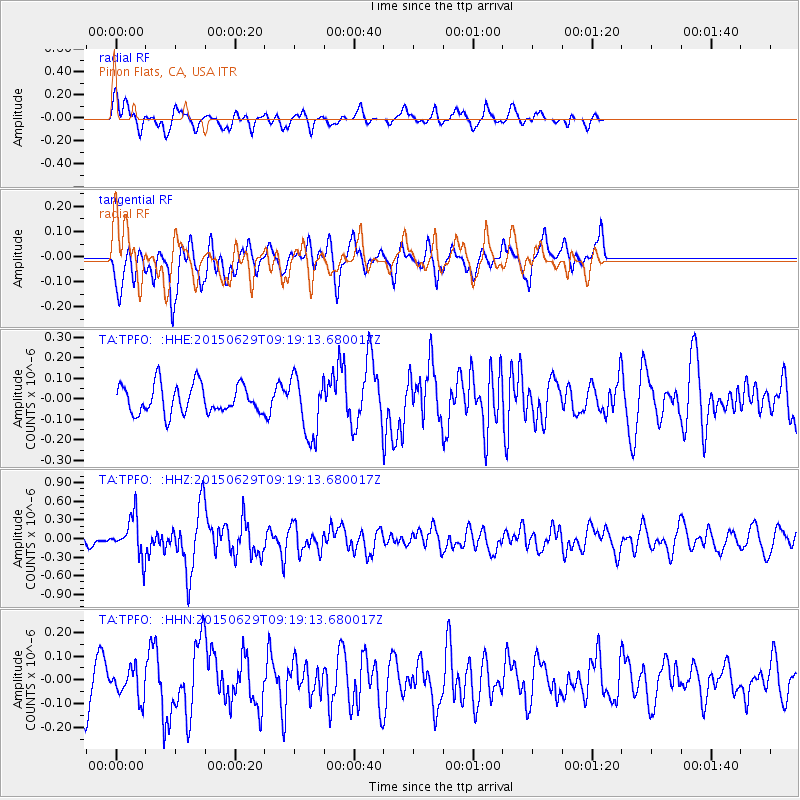
TPFO Pinon Flats, CA, USA - Earthquake Result Viewer
*The percent match for this event was below the threshold and hence no stack was calculated.
| Earthquake location: |
Near Coast Of Peru |
| Earthquake latitude/longitude: |
-16.0/-74.2 |
| Earthquake time(UTC): |
2015/06/29 (180) 09:09:15 GMT |
| Earthquake Depth: |
24 km |
| Earthquake Magnitude: |
5.5 MB |
| Earthquake Catalog/Contributor: |
NEIC PDE/NEIC ALERT |
|
| Network: |
TA USArray Transportable Network (new EarthScope stations) |
| Station: |
TPFO Pinon Flats, CA, USA |
| Lat/Lon: |
33.61 N/116.45 W |
| Elevation: |
1275 m |
|
| Distance: |
63.7 deg |
| Az: |
321.254 deg |
| Baz: |
133.848 deg |
| Ray Param: |
$rayparam |
*The percent match for this event was below the threshold and hence was not used in the summary stack. |
|
| Radial Match: |
63.972755 % |
| Radial Bump: |
400 |
| Transverse Match: |
70.941666 % |
| Transverse Bump: |
400 |
| SOD ConfigId: |
7422571 |
| Insert Time: |
2019-04-19 13:07:45.657 +0000 |
| GWidth: |
2.5 |
| Max Bumps: |
400 |
| Tol: |
0.001 |
|
Signal To Noise
| Channel | StoN | STA | LTA |
| TA:TPFO: :HHZ:20150629T09:19:13.680017Z | 3.6922352 | 3.1550013E-7 | 8.544963E-8 |
| TA:TPFO: :HHN:20150629T09:19:13.680017Z | 0.77665806 | 6.2535214E-8 | 8.051833E-8 |
| TA:TPFO: :HHE:20150629T09:19:13.680017Z | 2.066242 | 1.4437727E-7 | 6.987433E-8 |
| Arrivals |
| Ps | |
| PpPs | |
| PsPs/PpSs | |


