You are here: Home > Network List > TA - USArray Transportable Network (new EarthScope stations) Stations List
> Station Z41A Richland Creek Farm, El Dorado, AR, USA > Earthquake Result Viewer
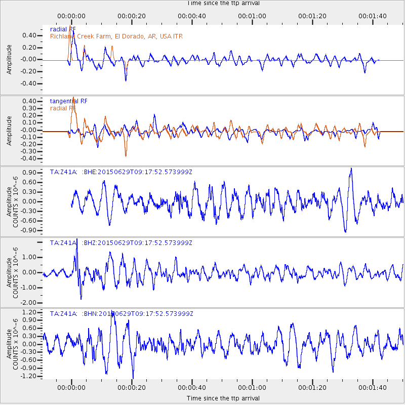
Z41A Richland Creek Farm, El Dorado, AR, USA - Earthquake Result Viewer
*The percent match for this event was below the threshold and hence no stack was calculated.
| Earthquake location: |
Near Coast Of Peru |
| Earthquake latitude/longitude: |
-16.0/-74.2 |
| Earthquake time(UTC): |
2015/06/29 (180) 09:09:15 GMT |
| Earthquake Depth: |
24 km |
| Earthquake Magnitude: |
5.5 MB |
| Earthquake Catalog/Contributor: |
NEIC PDE/NEIC ALERT |
|
| Network: |
TA USArray Transportable Network (new EarthScope stations) |
| Station: |
Z41A Richland Creek Farm, El Dorado, AR, USA |
| Lat/Lon: |
33.26 N/92.80 W |
| Elevation: |
62 m |
|
| Distance: |
52.1 deg |
| Az: |
340.216 deg |
| Baz: |
157.14 deg |
| Ray Param: |
$rayparam |
*The percent match for this event was below the threshold and hence was not used in the summary stack. |
|
| Radial Match: |
71.428085 % |
| Radial Bump: |
400 |
| Transverse Match: |
43.843296 % |
| Transverse Bump: |
400 |
| SOD ConfigId: |
7422571 |
| Insert Time: |
2019-04-19 13:07:50.113 +0000 |
| GWidth: |
2.5 |
| Max Bumps: |
400 |
| Tol: |
0.001 |
|
Signal To Noise
| Channel | StoN | STA | LTA |
| TA:Z41A: :BHZ:20150629T09:17:52.573999Z | 5.883472 | 7.8548396E-7 | 1.3350687E-7 |
| TA:Z41A: :BHN:20150629T09:17:52.573999Z | 1.0434204 | 3.058288E-7 | 2.9310215E-7 |
| TA:Z41A: :BHE:20150629T09:17:52.573999Z | 0.7062909 | 1.9526932E-7 | 2.7647152E-7 |
| Arrivals |
| Ps | |
| PpPs | |
| PsPs/PpSs | |


