You are here: Home > Network List > IU - Global Seismograph Network (GSN - IRIS/USGS) Stations List
> Station BILL Bilibino, Russia > Earthquake Result Viewer
BILL Bilibino, Russia - Earthquake Result Viewer
| Earthquake location: |
South Of Mariana Islands |
| Earthquake latitude/longitude: |
12.7/145.0 |
| Earthquake time(UTC): |
2001/10/12 (285) 15:02:16 GMT |
| Earthquake Depth: |
37 km |
| Earthquake Magnitude: |
6.7 MB, 7.3 MS, 7.0 MW, 6.9 MW |
| Earthquake Catalog/Contributor: |
WHDF/NEIC |
|
| Network: |
IU Global Seismograph Network (GSN - IRIS/USGS) |
| Station: |
BILL Bilibino, Russia |
| Lat/Lon: |
68.07 N/166.45 E |
| Elevation: |
299 m |
|
| Distance: |
57.1 deg |
| Az: |
9.43 deg |
| Baz: |
205.186 deg |
| Ray Param: |
0.063648105 |
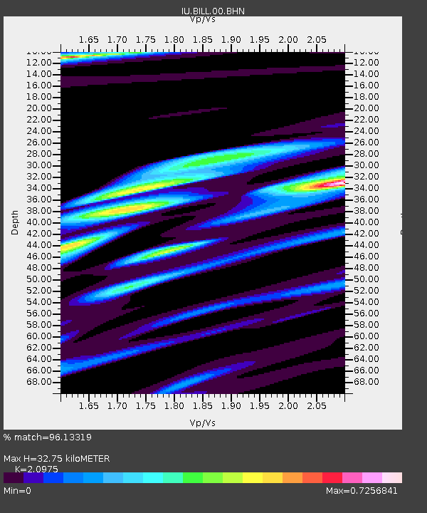
| Estimated Moho Depth: |
32.75 km |
| Estimated Crust Vp/Vs: |
2.10 |
| Assumed Crust Vp: |
6.577 km/s |
| Estimated Crust Vs: |
3.136 km/s |
| Estimated Crust Poisson's Ratio: |
0.35 |
|
| Radial Match: |
96.13319 % |
| Radial Bump: |
283 |
| Transverse Match: |
83.3084 % |
| Transverse Bump: |
400 |
| SOD ConfigId: |
20082 |
| Insert Time: |
2010-03-03 15:23:12.545 +0000 |
| GWidth: |
2.5 |
| Max Bumps: |
400 |
| Tol: |
0.001 |
|
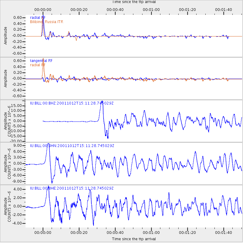
Signal To Noise
| Channel | StoN | STA | LTA |
| IU:BILL:00:BHN:20011012T15:11:28.745029Z | 35.089146 | 5.627811E-6 | 1.603861E-7 |
| IU:BILL:00:BHE:20011012T15:11:28.745029Z | 16.535513 | 2.4673504E-6 | 1.4921524E-7 |
| IU:BILL:00:BHZ:20011012T15:11:28.745029Z | 65.371 | 1.0715389E-5 | 1.6391655E-7 |
| Arrivals |
| Ps | 5.7 SECOND |
| PpPs | 15 SECOND |
| PsPs/PpSs | 20 SECOND |


