You are here: Home > Network List > UW - Pacific Northwest Regional Seismic Network Stations List
> Station MRBL Marblemount, WA, USA > Earthquake Result Viewer
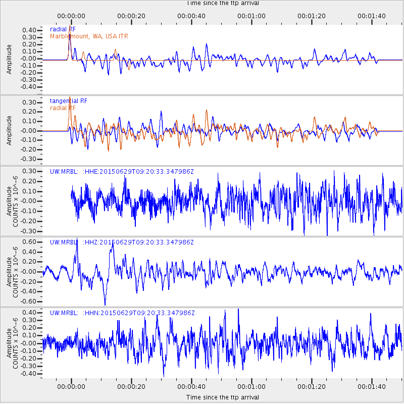
MRBL Marblemount, WA, USA - Earthquake Result Viewer
*The percent match for this event was below the threshold and hence no stack was calculated.
| Earthquake location: |
Near Coast Of Peru |
| Earthquake latitude/longitude: |
-16.0/-74.2 |
| Earthquake time(UTC): |
2015/06/29 (180) 09:09:15 GMT |
| Earthquake Depth: |
24 km |
| Earthquake Magnitude: |
5.5 MB |
| Earthquake Catalog/Contributor: |
NEIC PDE/NEIC ALERT |
|
| Network: |
UW Pacific Northwest Regional Seismic Network |
| Station: |
MRBL Marblemount, WA, USA |
| Lat/Lon: |
48.52 N/121.48 W |
| Elevation: |
75 m |
|
| Distance: |
76.8 deg |
| Az: |
329.884 deg |
| Baz: |
133.47 deg |
| Ray Param: |
$rayparam |
*The percent match for this event was below the threshold and hence was not used in the summary stack. |
|
| Radial Match: |
67.34329 % |
| Radial Bump: |
400 |
| Transverse Match: |
60.28812 % |
| Transverse Bump: |
400 |
| SOD ConfigId: |
7422571 |
| Insert Time: |
2019-04-19 13:08:32.769 +0000 |
| GWidth: |
2.5 |
| Max Bumps: |
400 |
| Tol: |
0.001 |
|
Signal To Noise
| Channel | StoN | STA | LTA |
| UW:MRBL: :HHZ:20150629T09:20:33.347986Z | 3.4254925 | 2.347356E-7 | 6.8526084E-8 |
| UW:MRBL: :HHN:20150629T09:20:33.347986Z | 1.2069663 | 8.0286696E-8 | 6.6519426E-8 |
| UW:MRBL: :HHE:20150629T09:20:33.347986Z | 0.9975988 | 8.028846E-8 | 8.0481705E-8 |
| Arrivals |
| Ps | |
| PpPs | |
| PsPs/PpSs | |


