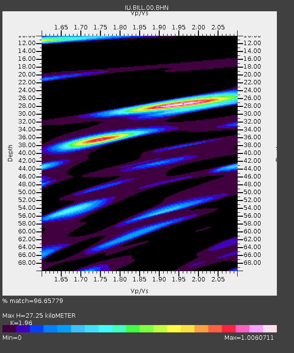
BILL Bilibino, Russia - Earthquake Result Viewer

Earthquake location: New Britain Region, P.N.G.
Earthquake latitude/longitude: -5.2/152.9
Earthquake time(UTC): 1999/05/17 (137) 10:07:56 GMT
Earthquake Depth: 27 km
Earthquake Magnitude: 5.5 MB, 6.9 MS, 6.7 MW, 6.0 ME
Earthquake Catalog/Contributor: WHDF/NEIC
Network: IU Global Seismograph Network (GSN - IRIS/USGS)
Station: BILL Bilibino, Russia
Lat/Lon: 68.07 N/166.45 E
Elevation: 299 m
Distance: 73.7 deg
Az: 5.272 deg
Baz: 194.099 deg
Ray Param: 0.052803144
Estimated Moho Depth: 27.25 km
Estimated Crust Vp/Vs: 1.96
Assumed Crust Vp: 6.577 km/s
Estimated Crust Vs: 3.355 km/s
Estimated Crust Poisson's Ratio: 0.32
Radial Match: 96.65779 %
Radial Bump: 397
Transverse Match: 80.79862 %
Transverse Bump: 400
SOD ConfigId: 4480
Insert Time: 2010-03-03 15:23:57.154 +0000
GWidth: 2.5
Max Bumps: 400
Tol: 0.001

Signal To Noise

ChannelStoNSTALTA
IU:BILL:00:BHN:19990517T10:18:56.582019Z64.629593.8571434E-65.9680765E-8
IU:BILL:00:BHE:19990517T10:18:56.582019Z21.9914511.884964E-68.5713495E-8
IU:BILL:00:BHZ:19990517T10:18:56.582019Z6.0457264.472399E-77.397621E-8
Arrivals
Ps4.1 SECOND
PpPs12 SECOND
PsPs/PpSs16 SECOND