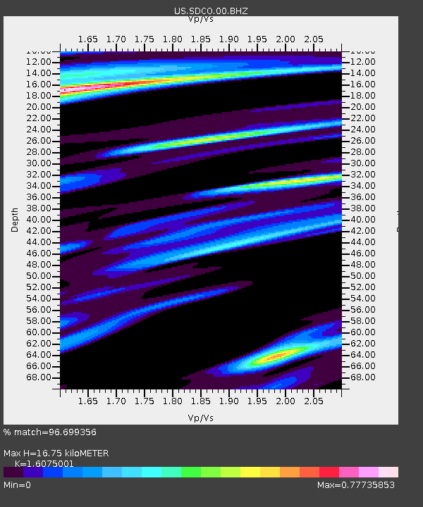
SDCO Great Sand Dunes National Park, Colorado, USA - Earthquake Result Viewer
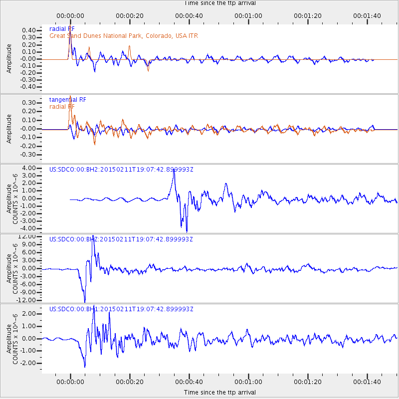
Earthquake location: Jujuy Province, Argentina
Earthquake latitude/longitude: -23.1/-66.7
Earthquake time(UTC): 2015/02/11 (042) 18:57:22 GMT
Earthquake Depth: 223 km
Earthquake Magnitude: 6.7 MWW, 6.7 MWC, 6.7 MWB, 6.9 MI
Earthquake Catalog/Contributor: NEIC PDE/NEIC COMCAT
Network: US United States National Seismic Network
Station: SDCO Great Sand Dunes National Park, Colorado, USA
Lat/Lon: 37.75 N/105.50 W
Elevation: 2569 m
Distance: 70.7 deg
Az: 328.232 deg
Baz: 142.302 deg
Ray Param: 0.0542008
Estimated Moho Depth: 16.75 km
Estimated Crust Vp/Vs: 1.61
Assumed Crust Vp: 6.316 km/s
Estimated Crust Vs: 3.929 km/s
Estimated Crust Poisson's Ratio: 0.18
Radial Match: 96.699356 %
Radial Bump: 369
Transverse Match: 89.82249 %
Transverse Bump: 400
SOD ConfigId: 872571
Insert Time: 2015-02-25 19:08:16.078 +0000
GWidth: 2.5
Max Bumps: 400
Tol: 0.001

Signal To Noise

ChannelStoNSTALTA
US:SDCO:00:BHZ:20150211T19:07:42.899993Z41.783354.129029E-69.881996E-8
US:SDCO:00:BH1:20150211T19:07:42.899993Z8.6710847.576138E-78.737244E-8
US:SDCO:00:BH2:20150211T19:07:42.899993Z7.9888291.1227356E-61.4053819E-7
Arrivals
Ps1.7 SECOND
PpPs6.7 SECOND
PsPs/PpSs8.3 SECOND