You are here: Home > Network List > CN - Canadian National Seismograph Network Stations List
> Station INK INUVIK, NT > Earthquake Result Viewer
INK INUVIK, NT - Earthquake Result Viewer
*The percent match for this event was below the threshold and hence no stack was calculated.
| Earthquake location: |
Afghanistan-Tajikistan Bord Reg. |
| Earthquake latitude/longitude: |
36.7/71.3 |
| Earthquake time(UTC): |
2015/06/29 (180) 22:07:48 GMT |
| Earthquake Depth: |
190 km |
| Earthquake Magnitude: |
5.5 MB |
| Earthquake Catalog/Contributor: |
NEIC PDE/NEIC ALERT |
|
| Network: |
CN Canadian National Seismograph Network |
| Station: |
INK INUVIK, NT |
| Lat/Lon: |
68.31 N/133.53 W |
| Elevation: |
44 m |
|
| Distance: |
73.7 deg |
| Az: |
9.355 deg |
| Baz: |
339.426 deg |
| Ray Param: |
$rayparam |
*The percent match for this event was below the threshold and hence was not used in the summary stack. |
|
| Radial Match: |
64.37198 % |
| Radial Bump: |
396 |
| Transverse Match: |
60.81057 % |
| Transverse Bump: |
400 |
| SOD ConfigId: |
7422571 |
| Insert Time: |
2019-04-19 13:12:48.870 +0000 |
| GWidth: |
2.5 |
| Max Bumps: |
400 |
| Tol: |
0.001 |
|
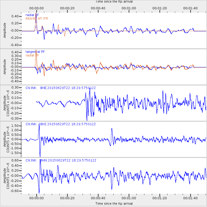
Signal To Noise
| Channel | StoN | STA | LTA |
| CN:INK: :BHZ:20150629T22:18:29.575012Z | 18.322378 | 7.141027E-7 | 3.897435E-8 |
| CN:INK: :BHN:20150629T22:18:29.575012Z | 3.14694 | 2.870802E-7 | 9.1225196E-8 |
| CN:INK: :BHE:20150629T22:18:29.575012Z | 4.8050156 | 1.3879497E-7 | 2.8885438E-8 |
| Arrivals |
| Ps | |
| PpPs | |
| PsPs/PpSs | |


