You are here: Home > Network List > TA - USArray Transportable Network (new EarthScope stations) Stations List
> Station N25K Chitina, Valdez-Cordova, AK, USA > Earthquake Result Viewer
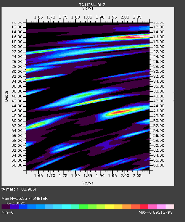
N25K Chitina, Valdez-Cordova, AK, USA - Earthquake Result Viewer
| Earthquake location: |
Afghanistan-Tajikistan Bord Reg. |
| Earthquake latitude/longitude: |
36.7/71.3 |
| Earthquake time(UTC): |
2015/06/29 (180) 22:07:48 GMT |
| Earthquake Depth: |
190 km |
| Earthquake Magnitude: |
5.5 MB |
| Earthquake Catalog/Contributor: |
NEIC PDE/NEIC ALERT |
|
| Network: |
TA USArray Transportable Network (new EarthScope stations) |
| Station: |
N25K Chitina, Valdez-Cordova, AK, USA |
| Lat/Lon: |
61.61 N/144.60 W |
| Elevation: |
1087 m |
|
| Distance: |
77.8 deg |
| Az: |
16.657 deg |
| Baz: |
331.185 deg |
| Ray Param: |
0.04959322 |
| Estimated Moho Depth: |
15.25 km |
| Estimated Crust Vp/Vs: |
2.09 |
| Assumed Crust Vp: |
6.566 km/s |
| Estimated Crust Vs: |
3.138 km/s |
| Estimated Crust Poisson's Ratio: |
0.35 |
|
| Radial Match: |
83.9059 % |
| Radial Bump: |
400 |
| Transverse Match: |
76.818535 % |
| Transverse Bump: |
400 |
| SOD ConfigId: |
7422571 |
| Insert Time: |
2019-04-19 13:15:52.503 +0000 |
| GWidth: |
2.5 |
| Max Bumps: |
400 |
| Tol: |
0.001 |
|

Signal To Noise
| Channel | StoN | STA | LTA |
| TA:N25K: :BHZ:20150629T22:18:52.799988Z | 9.907713 | 5.035049E-7 | 5.0819487E-8 |
| TA:N25K: :BHN:20150629T22:18:52.799988Z | 6.2631893 | 2.9773446E-7 | 4.7537196E-8 |
| TA:N25K: :BHE:20150629T22:18:52.799988Z | 1.578438 | 1.0302101E-7 | 6.52677E-8 |
| Arrivals |
| Ps | 2.6 SECOND |
| PpPs | 7.0 SECOND |
| PsPs/PpSs | 9.6 SECOND |


