You are here: Home > Network List > UU - University of Utah Regional Network Stations List
> Station PSUT Pine Spring, UT, USA > Earthquake Result Viewer
PSUT Pine Spring, UT, USA - Earthquake Result Viewer

| Earthquake location: |
Jujuy Province, Argentina |
| Earthquake latitude/longitude: |
-23.1/-66.7 |
| Earthquake time(UTC): |
2015/02/11 (042) 18:57:22 GMT |
| Earthquake Depth: |
223 km |
| Earthquake Magnitude: |
6.7 MWW, 6.7 MWC, 6.7 MWB, 6.9 MI |
| Earthquake Catalog/Contributor: |
NEIC PDE/NEIC COMCAT |
|
| Network: |
UU University of Utah Regional Network |
| Station: |
PSUT Pine Spring, UT, USA |
| Lat/Lon: |
38.53 N/113.85 W |
| Elevation: |
1999 m |
|
| Distance: |
75.6 deg |
| Az: |
323.574 deg |
| Baz: |
135.805 deg |
| Ray Param: |
0.0509721 |
| Estimated Moho Depth: |
54.5 km |
| Estimated Crust Vp/Vs: |
1.68 |
| Assumed Crust Vp: |
6.276 km/s |
| Estimated Crust Vs: |
3.736 km/s |
| Estimated Crust Poisson's Ratio: |
0.23 |
|
| Radial Match: |
86.9847 % |
| Radial Bump: |
400 |
| Transverse Match: |
77.59205 % |
| Transverse Bump: |
400 |
| SOD ConfigId: |
872571 |
| Insert Time: |
2015-02-25 19:09:54.377 +0000 |
| GWidth: |
2.5 |
| Max Bumps: |
400 |
| Tol: |
0.001 |
|
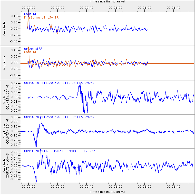
Signal To Noise
| Channel | StoN | STA | LTA |
| UU:PSUT:01:HHZ:20150211T19:08:11.517974Z | 34.441925 | 8.175988E-8 | 2.3738476E-9 |
| UU:PSUT:01:HHN:20150211T19:08:11.517974Z | 5.5968547 | 2.066222E-8 | 3.6917558E-9 |
| UU:PSUT:01:HHE:20150211T19:08:11.517974Z | 3.5441675 | 2.2374355E-8 | 6.313007E-9 |
| Arrivals |
| Ps | 6.1 SECOND |
| PpPs | 23 SECOND |
| PsPs/PpSs | 29 SECOND |


