You are here: Home > Network List > XD14 - Illuminating the architecture of the greater Mount St. Helens magmatic systems f Stations List
> Station MH01 "Mount St Helens, WA" > Earthquake Result Viewer
MH01 "Mount St Helens, WA" - Earthquake Result Viewer
| Earthquake location: |
South Of Kermadec Islands |
| Earthquake latitude/longitude: |
-32.4/-177.8 |
| Earthquake time(UTC): |
2015/06/30 (181) 12:19:16 GMT |
| Earthquake Depth: |
9.9 km |
| Earthquake Magnitude: |
5.3 MW, 5.2 mb, 5.0 MS |
| Earthquake Catalog/Contributor: |
ISC/ISC |
|
| Network: |
XD Illuminating the architecture of the greater Mount St. Helens magmatic systems f |
| Station: |
MH01 "Mount St Helens, WA" |
| Lat/Lon: |
46.26 N/122.81 W |
| Elevation: |
197 m |
|
| Distance: |
92.7 deg |
| Az: |
34.693 deg |
| Baz: |
223.975 deg |
| Ray Param: |
0.0414058 |
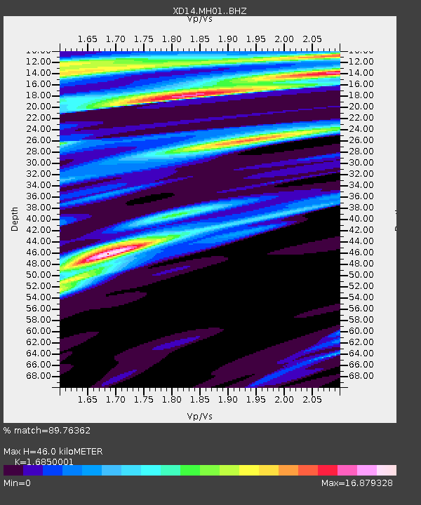
| Estimated Moho Depth: |
46.0 km |
| Estimated Crust Vp/Vs: |
1.69 |
| Assumed Crust Vp: |
6.566 km/s |
| Estimated Crust Vs: |
3.897 km/s |
| Estimated Crust Poisson's Ratio: |
0.23 |
|
| Radial Match: |
89.76362 % |
| Radial Bump: |
323 |
| Transverse Match: |
86.01453 % |
| Transverse Bump: |
333 |
| SOD ConfigId: |
7422571 |
| Insert Time: |
2019-04-19 13:32:00.413 +0000 |
| GWidth: |
2.5 |
| Max Bumps: |
400 |
| Tol: |
0.001 |
|

Signal To Noise
| Channel | StoN | STA | LTA |
| XD:MH01: :BHZ:20150630T12:31:56.665024Z | 2.2268772 | 2.1909327E-7 | 9.838588E-8 |
| XD:MH01: :BHN:20150630T12:31:56.665024Z | 2.9395618 | 3.5897956E-6 | 1.2212009E-6 |
| XD:MH01: :BHE:20150630T12:31:56.665024Z | 3.2878609 | 1.6094789E-6 | 4.895216E-7 |
| Arrivals |
| Ps | 4.9 SECOND |
| PpPs | 18 SECOND |
| PsPs/PpSs | 23 SECOND |


