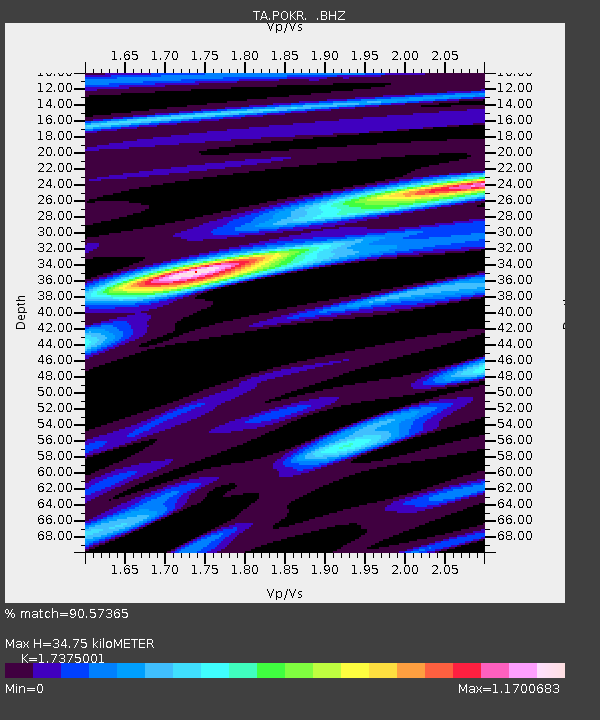
POKR Poker Plat Research Range, AK, USA - Earthquake Result Viewer
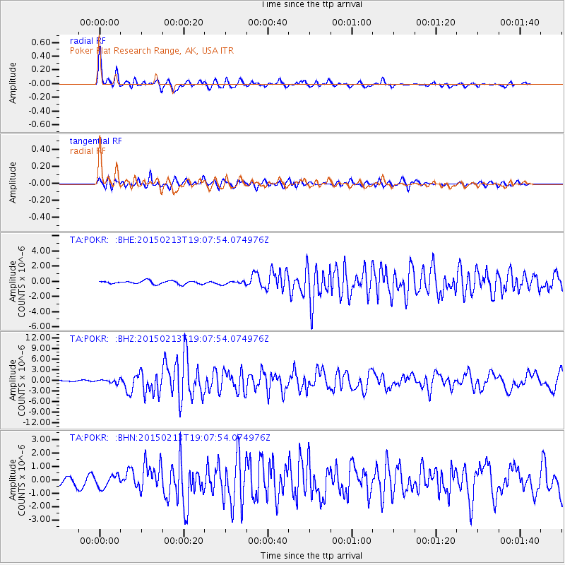
Earthquake location: Northern Mid-Atlantic Ridge
Earthquake latitude/longitude: 52.6/-31.9
Earthquake time(UTC): 2015/02/13 (044) 18:59:12 GMT
Earthquake Depth: 16 km
Earthquake Magnitude: 7.1 MWW, 6.8 MI, 7.0 MWB, 7.0 MWC, 7.1 MWC
Earthquake Catalog/Contributor: NEIC PDE/NEIC COMCAT
Network: TA USArray Transportable Network (new EarthScope stations)
Station: POKR Poker Plat Research Range, AK, USA
Lat/Lon: 65.12 N/147.43 W
Elevation: 501 m
Distance: 52.6 deg
Az: 331.288 deg
Baz: 43.789 deg
Ray Param: 0.066629775
Estimated Moho Depth: 34.75 km
Estimated Crust Vp/Vs: 1.74
Assumed Crust Vp: 6.566 km/s
Estimated Crust Vs: 3.779 km/s
Estimated Crust Poisson's Ratio: 0.25
Radial Match: 90.57365 %
Radial Bump: 400
Transverse Match: 81.67831 %
Transverse Bump: 400
SOD ConfigId: 872571
Insert Time: 2015-02-27 19:19:06.560 +0000
GWidth: 2.5
Max Bumps: 400
Tol: 0.001

Signal To Noise

ChannelStoNSTALTA
TA:POKR: :BHZ:20150213T19:07:54.074976Z2.2222294.736246E-72.131304E-7
TA:POKR: :BHN:20150213T19:07:54.074976Z1.83064974.6321057E-72.530307E-7
TA:POKR: :BHE:20150213T19:07:54.074976Z0.94999811.9850546E-72.0895354E-7
Arrivals
Ps4.1 SECOND
PpPs14 SECOND
PsPs/PpSs18 SECOND