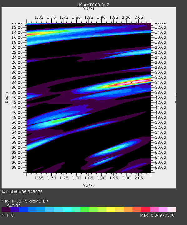
AMTX Amarillo, Texas, USA - Earthquake Result Viewer
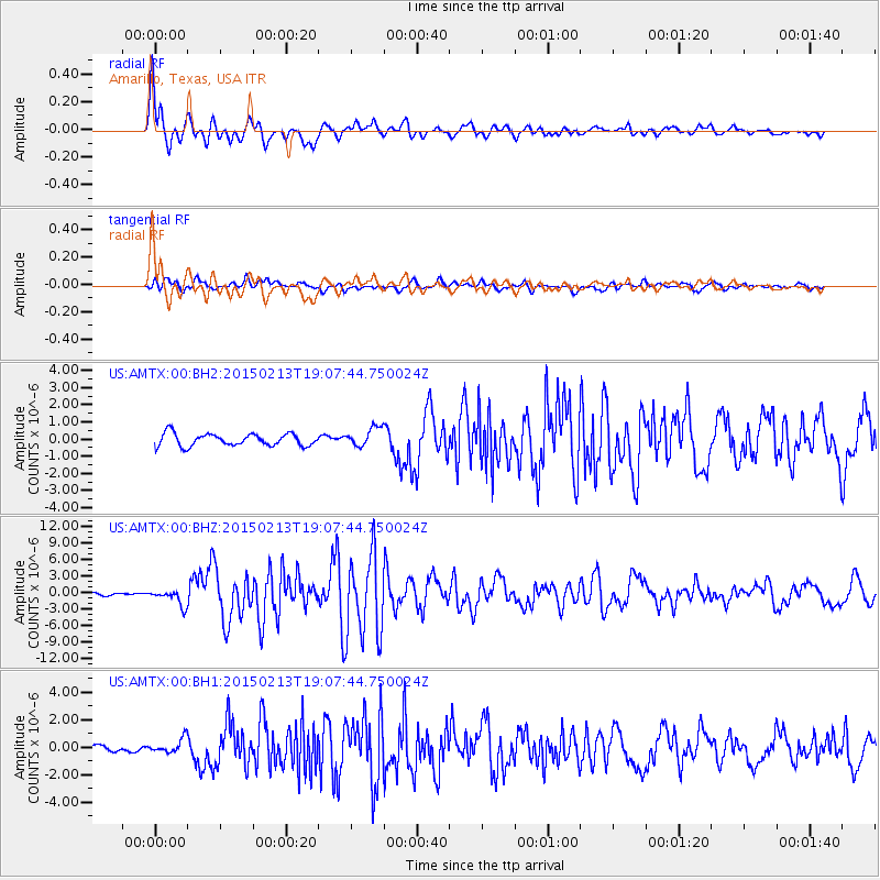
Earthquake location: Northern Mid-Atlantic Ridge
Earthquake latitude/longitude: 52.6/-31.9
Earthquake time(UTC): 2015/02/13 (044) 18:59:12 GMT
Earthquake Depth: 16 km
Earthquake Magnitude: 7.1 MWW, 6.8 MI, 7.0 MWB, 7.0 MWC, 7.1 MWC
Earthquake Catalog/Contributor: NEIC PDE/NEIC COMCAT
Network: US United States National Seismic Network
Station: AMTX Amarillo, Texas, USA
Lat/Lon: 34.53 N/101.41 W
Elevation: 1010 m
Distance: 51.4 deg
Az: 278.452 deg
Baz: 46.902 deg
Ray Param: 0.067399405
Estimated Moho Depth: 33.75 km
Estimated Crust Vp/Vs: 2.02
Assumed Crust Vp: 6.426 km/s
Estimated Crust Vs: 3.181 km/s
Estimated Crust Poisson's Ratio: 0.34
Radial Match: 86.945076 %
Radial Bump: 395
Transverse Match: 74.803246 %
Transverse Bump: 400
SOD ConfigId: 872571
Insert Time: 2015-02-27 19:19:19.855 +0000
GWidth: 2.5
Max Bumps: 400
Tol: 0.001

Signal To Noise

ChannelStoNSTALTA
US:AMTX:00:BHZ:20150213T19:07:44.750024Z3.79369691.4087034E-63.7132733E-7
US:AMTX:00:BH1:20150213T19:07:44.750024Z1.30536295.090487E-73.8996714E-7
US:AMTX:00:BH2:20150213T19:07:44.750024Z1.74691756.0503663E-73.463453E-7
Arrivals
Ps5.6 SECOND
PpPs15 SECOND
PsPs/PpSs21 SECOND