You are here: Home > Network List > US - United States National Seismic Network Stations List
> Station HAWA Hanford, Washington, USA > Earthquake Result Viewer
HAWA Hanford, Washington, USA - Earthquake Result Viewer
*The percent match for this event was below the threshold and hence no stack was calculated.
| Earthquake location: |
Northern Mid-Atlantic Ridge |
| Earthquake latitude/longitude: |
52.6/-31.9 |
| Earthquake time(UTC): |
2015/02/13 (044) 18:59:12 GMT |
| Earthquake Depth: |
16 km |
| Earthquake Magnitude: |
7.1 MWW, 6.8 MI, 7.0 MWB, 7.0 MWC, 7.1 MWC |
| Earthquake Catalog/Contributor: |
NEIC PDE/NEIC COMCAT |
|
| Network: |
US United States National Seismic Network |
| Station: |
HAWA Hanford, Washington, USA |
| Lat/Lon: |
46.39 N/119.53 W |
| Elevation: |
364 m |
|
| Distance: |
53.9 deg |
| Az: |
301.112 deg |
| Baz: |
48.928 deg |
| Ray Param: |
$rayparam |
*The percent match for this event was below the threshold and hence was not used in the summary stack. |
|
| Radial Match: |
72.777885 % |
| Radial Bump: |
400 |
| Transverse Match: |
62.29081 % |
| Transverse Bump: |
400 |
| SOD ConfigId: |
872571 |
| Insert Time: |
2015-02-27 19:20:01.079 +0000 |
| GWidth: |
2.5 |
| Max Bumps: |
400 |
| Tol: |
0.001 |
|
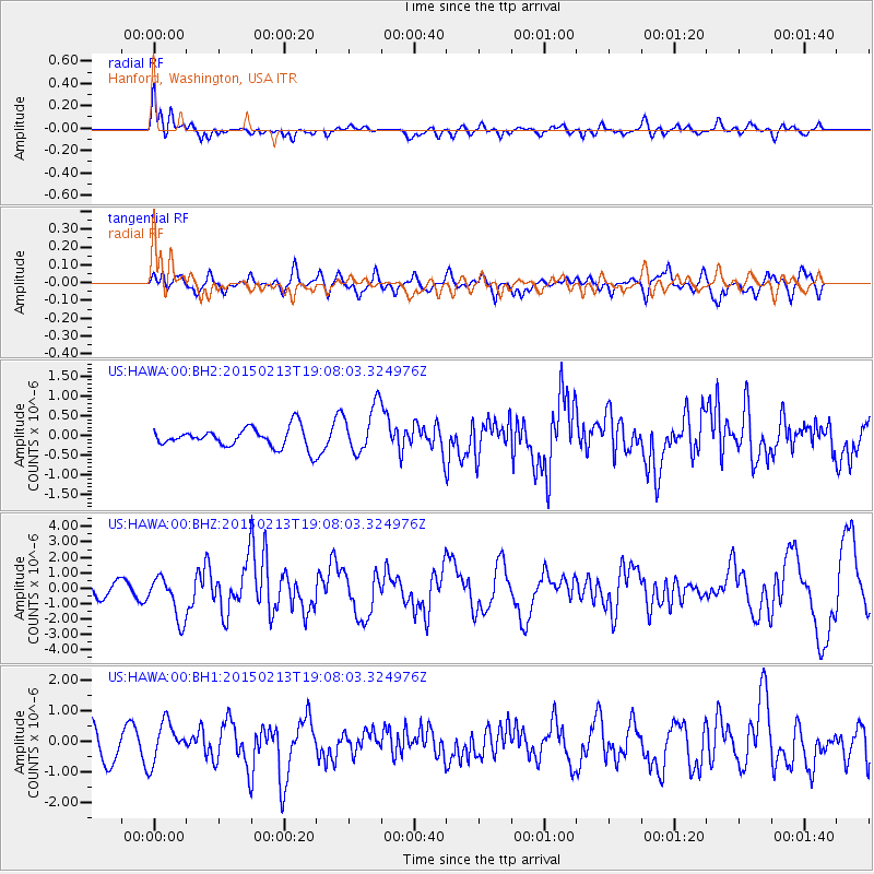
Signal To Noise
| Channel | StoN | STA | LTA |
| US:HAWA:00:BHZ:20150213T19:08:03.324976Z | 3.7782958 | 1.4056473E-6 | 3.720321E-7 |
| US:HAWA:00:BH1:20150213T19:08:03.324976Z | 1.4987133 | 6.468576E-7 | 4.3160867E-7 |
| US:HAWA:00:BH2:20150213T19:08:03.324976Z | 2.4619913 | 6.060072E-7 | 2.4614513E-7 |
| Arrivals |
| Ps | |
| PpPs | |
| PsPs/PpSs | |


