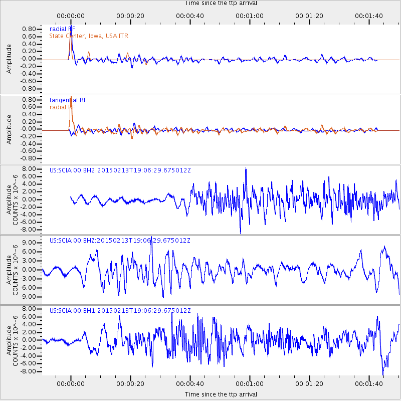
SCIA State Center, Iowa, USA - Earthquake Result Viewer
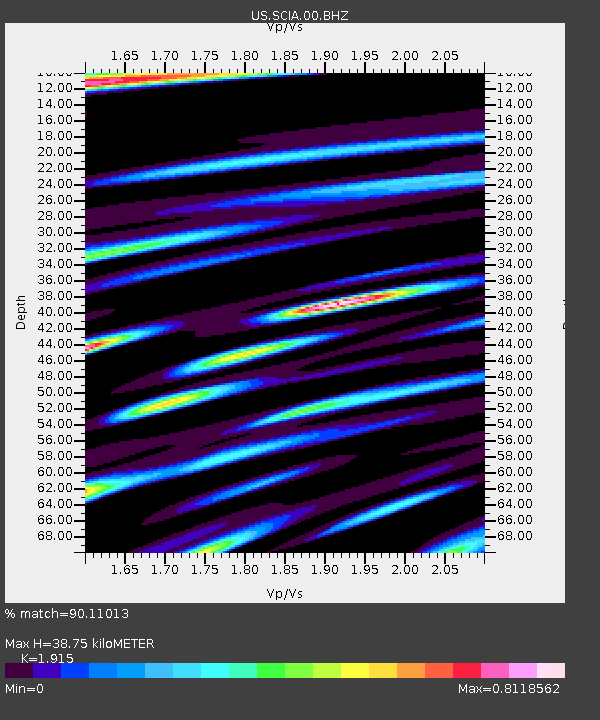
Earthquake location: Northern Mid-Atlantic Ridge
Earthquake latitude/longitude: 52.6/-31.9
Earthquake time(UTC): 2015/02/13 (044) 18:59:12 GMT
Earthquake Depth: 16 km
Earthquake Magnitude: 7.1 MWW, 6.8 MI, 7.0 MWB, 7.0 MWC, 7.1 MWC
Earthquake Catalog/Contributor: NEIC PDE/NEIC COMCAT
Network: US United States National Seismic Network
Station: SCIA State Center, Iowa, USA
Lat/Lon: 41.91 N/93.22 W
Elevation: 312 m
Distance: 41.8 deg
Az: 280.522 deg
Baz: 53.393 deg
Ray Param: 0.07356393
Estimated Moho Depth: 38.75 km
Estimated Crust Vp/Vs: 1.91
Assumed Crust Vp: 6.498 km/s
Estimated Crust Vs: 3.393 km/s
Estimated Crust Poisson's Ratio: 0.31
Radial Match: 90.11013 %
Radial Bump: 400
Transverse Match: 61.383068 %
Transverse Bump: 400
SOD ConfigId: 872571
Insert Time: 2015-02-27 19:20:43.312 +0000
GWidth: 2.5
Max Bumps: 400
Tol: 0.001

Signal To Noise

ChannelStoNSTALTA
US:SCIA:00:BHZ:20150213T19:06:29.675012Z2.74650882.1853996E-67.957009E-7
US:SCIA:00:BH1:20150213T19:06:29.675012Z1.30338518.6302157E-76.621386E-7
US:SCIA:00:BH2:20150213T19:06:29.675012Z1.35882828.7167723E-76.414919E-7
Arrivals
Ps5.8 SECOND
PpPs16 SECOND
PsPs/PpSs22 SECOND