You are here: Home > Network List > UU - University of Utah Regional Network Stations List
> Station HVU Hansel Valley, UT, USA > Earthquake Result Viewer
HVU Hansel Valley, UT, USA - Earthquake Result Viewer
| Earthquake location: |
Northern Mid-Atlantic Ridge |
| Earthquake latitude/longitude: |
52.6/-31.9 |
| Earthquake time(UTC): |
2015/02/13 (044) 18:59:12 GMT |
| Earthquake Depth: |
16 km |
| Earthquake Magnitude: |
7.1 MWW, 6.8 MI, 7.0 MWB, 7.0 MWC, 7.1 MWC |
| Earthquake Catalog/Contributor: |
NEIC PDE/NEIC COMCAT |
|
| Network: |
UU University of Utah Regional Network |
| Station: |
HVU Hansel Valley, UT, USA |
| Lat/Lon: |
41.78 N/112.78 W |
| Elevation: |
1609 m |
|
| Distance: |
53.2 deg |
| Az: |
292.816 deg |
| Baz: |
48.686 deg |
| Ray Param: |
0.06621432 |
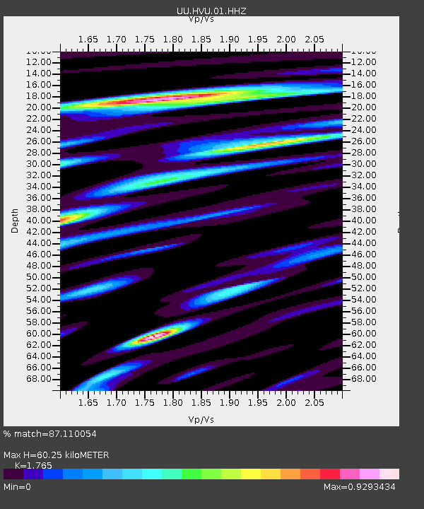
| Estimated Moho Depth: |
60.25 km |
| Estimated Crust Vp/Vs: |
1.76 |
| Assumed Crust Vp: |
6.276 km/s |
| Estimated Crust Vs: |
3.556 km/s |
| Estimated Crust Poisson's Ratio: |
0.26 |
|
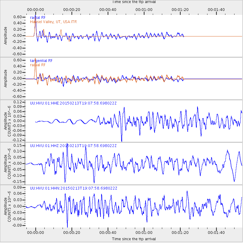
| Radial Match: |
87.110054 % |
| Radial Bump: |
400 |
| Transverse Match: |
66.49763 % |
| Transverse Bump: |
400 |
| SOD ConfigId: |
872571 |
| Insert Time: |
2015-02-27 19:21:18.300 +0000 |
| GWidth: |
2.5 |
| Max Bumps: |
400 |
| Tol: |
0.001 |
|
Signal To Noise
| Channel | StoN | STA | LTA |
| UU:HVU:01:HHZ:20150213T19:07:58.698022Z | 6.221653 | 2.8961697E-8 | 4.654984E-9 |
| UU:HVU:01:HHN:20150213T19:07:58.698022Z | 1.9520077 | 9.1208125E-9 | 4.672529E-9 |
| UU:HVU:01:HHE:20150213T19:07:58.698022Z | 1.6232433 | 1.208379E-8 | 7.444226E-9 |
| Arrivals |
| Ps | 7.7 SECOND |
| PpPs | 25 SECOND |
| PsPs/PpSs | 33 SECOND |


