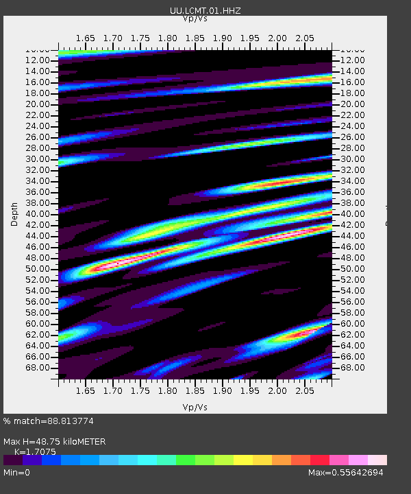
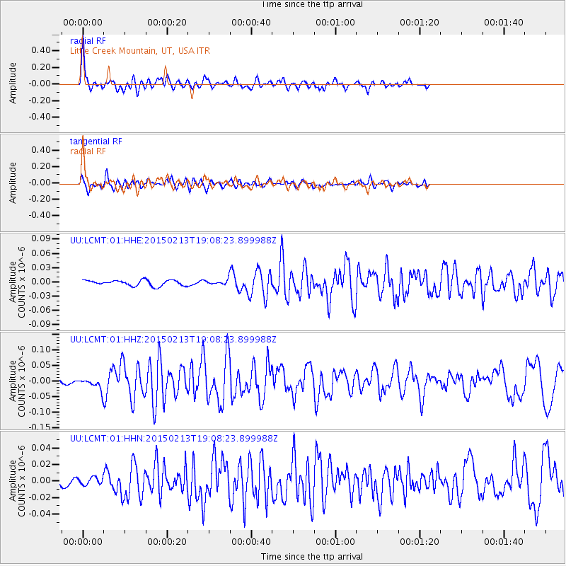
LCMT Little Creek Mountain, UT, USA - Earthquake Result Viewer

Earthquake location: Northern Mid-Atlantic Ridge
Earthquake latitude/longitude: 52.6/-31.9
Earthquake time(UTC): 2015/02/13 (044) 18:59:12 GMT
Earthquake Depth: 16 km
Earthquake Magnitude: 7.1 MWW, 6.8 MI, 7.0 MWB, 7.0 MWC, 7.1 MWC
Earthquake Catalog/Contributor: NEIC PDE/NEIC COMCAT
Network: UU University of Utah Regional Network
Station: LCMT Little Creek Mountain, UT, USA
Lat/Lon: 37.01 N/113.24 W
Elevation: 1411 m
Distance: 56.7 deg
Az: 288.837 deg
Baz: 46.105 deg
Ray Param: 0.06393183
Estimated Moho Depth: 48.75 km
Estimated Crust Vp/Vs: 1.71
Assumed Crust Vp: 6.194 km/s
Estimated Crust Vs: 3.628 km/s
Estimated Crust Poisson's Ratio: 0.24
Radial Match: 88.813774 %
Radial Bump: 400
Transverse Match: 80.42125 %
Transverse Bump: 400
SOD ConfigId: 872571
Insert Time: 2015-02-27 19:21:25.602 +0000
GWidth: 2.5
Max Bumps: 400
Tol: 0.001

Signal To Noise

ChannelStoNSTALTA
UU:LCMT:01:HHZ:20150213T19:08:23.899988Z2.60425451.7798229E-86.8342887E-9
UU:LCMT:01:HHN:20150213T19:08:23.899988Z0.61107754.3599857E-97.1349144E-9
UU:LCMT:01:HHE:20150213T19:08:23.899988Z0.84363494.939081E-95.854525E-9
Arrivals
Ps5.8 SECOND
PpPs20 SECOND
PsPs/PpSs26 SECOND