You are here: Home > Network List > AK - Alaska Regional Network Stations List
> Station MLY Manley Hot Springs, Alaska, USA > Earthquake Result Viewer
MLY Manley Hot Springs, Alaska, USA - Earthquake Result Viewer
| Earthquake location: |
Solomon Islands |
| Earthquake latitude/longitude: |
-11.0/162.6 |
| Earthquake time(UTC): |
2015/07/01 (182) 19:35:21 GMT |
| Earthquake Depth: |
8.9 km |
| Earthquake Magnitude: |
5.8 MO |
| Earthquake Catalog/Contributor: |
NEIC PDE/NEIC ALERT |
|
| Network: |
AK Alaska Regional Network |
| Station: |
MLY Manley Hot Springs, Alaska, USA |
| Lat/Lon: |
65.03 N/150.74 W |
| Elevation: |
804 m |
|
| Distance: |
83.4 deg |
| Az: |
18.116 deg |
| Baz: |
225.995 deg |
| Ray Param: |
0.04618988 |
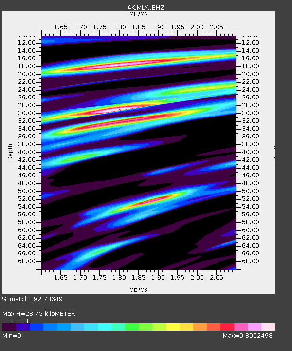
| Estimated Moho Depth: |
28.75 km |
| Estimated Crust Vp/Vs: |
1.80 |
| Assumed Crust Vp: |
6.566 km/s |
| Estimated Crust Vs: |
3.648 km/s |
| Estimated Crust Poisson's Ratio: |
0.28 |
|
| Radial Match: |
92.78649 % |
| Radial Bump: |
382 |
| Transverse Match: |
86.49977 % |
| Transverse Bump: |
400 |
| SOD ConfigId: |
7422571 |
| Insert Time: |
2019-04-19 13:51:15.788 +0000 |
| GWidth: |
2.5 |
| Max Bumps: |
400 |
| Tol: |
0.001 |
|

Signal To Noise
| Channel | StoN | STA | LTA |
| AK:MLY: :BHZ:20150701T19:47:16.947998Z | 11.955626 | 7.3122817E-7 | 6.116185E-8 |
| AK:MLY: :BHN:20150701T19:47:16.947998Z | 4.892826 | 1.7900977E-7 | 3.6586172E-8 |
| AK:MLY: :BHE:20150701T19:47:16.947998Z | 4.4647326 | 1.5686508E-7 | 3.513426E-8 |
| Arrivals |
| Ps | 3.6 SECOND |
| PpPs | 12 SECOND |
| PsPs/PpSs | 16 SECOND |


