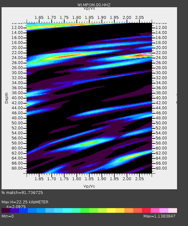
MPOM Morne Pois, Sainte-Anne, Martinique - Earthquake Result Viewer

Earthquake location: Northern Mid-Atlantic Ridge
Earthquake latitude/longitude: 52.6/-31.9
Earthquake time(UTC): 2015/02/13 (044) 18:59:12 GMT
Earthquake Depth: 16 km
Earthquake Magnitude: 7.1 MWW, 6.8 MI, 7.0 MWB, 7.0 MWC, 7.1 MWC
Earthquake Catalog/Contributor: NEIC PDE/NEIC COMCAT
Network: WI West Indies IPGP Network
Station: MPOM Morne Pois, Sainte-Anne, Martinique
Lat/Lon: 14.45 N/60.86 W
Elevation: 50 m
Distance: 44.5 deg
Az: 222.021 deg
Baz: 24.905 deg
Ray Param: 0.07185356
Estimated Moho Depth: 22.25 km
Estimated Crust Vp/Vs: 2.10
Assumed Crust Vp: 5.88 km/s
Estimated Crust Vs: 2.804 km/s
Estimated Crust Poisson's Ratio: 0.35
Radial Match: 91.736725 %
Radial Bump: 325
Transverse Match: 78.41166 %
Transverse Bump: 400
SOD ConfigId: 872571
Insert Time: 2015-02-27 19:23:26.191 +0000
GWidth: 2.5
Max Bumps: 400
Tol: 0.001

Signal To Noise

ChannelStoNSTALTA
WI:MPOM:00:HHZ:20150213T19:06:51.820001Z3.80948698.815467E-72.3140826E-7
WI:MPOM:00:HHN:20150213T19:06:51.820001Z1.60662834.2121178E-72.6217128E-7
WI:MPOM:00:HHE:20150213T19:06:51.820001Z1.96790734.880919E-72.4802588E-7
Arrivals
Ps4.3 SECOND
PpPs11 SECOND
PsPs/PpSs16 SECOND