You are here: Home > Network List > TA - USArray Transportable Network (new EarthScope stations) Stations List
> Station A21K Barrow, AK, USA > Earthquake Result Viewer
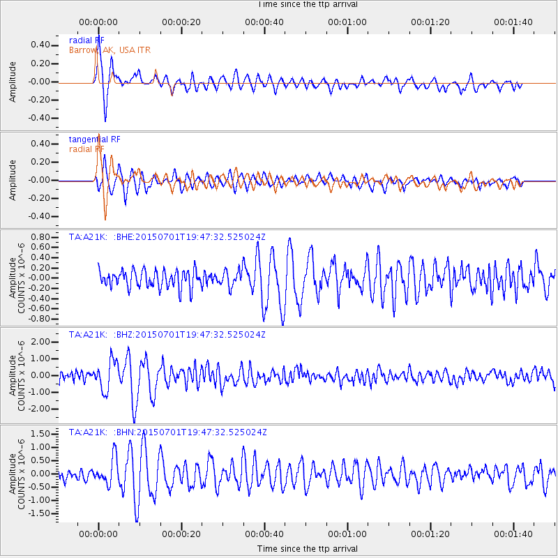
A21K Barrow, AK, USA - Earthquake Result Viewer
| Earthquake location: |
Solomon Islands |
| Earthquake latitude/longitude: |
-11.0/162.6 |
| Earthquake time(UTC): |
2015/07/01 (182) 19:35:21 GMT |
| Earthquake Depth: |
8.9 km |
| Earthquake Magnitude: |
5.8 MO |
| Earthquake Catalog/Contributor: |
NEIC PDE/NEIC ALERT |
|
| Network: |
TA USArray Transportable Network (new EarthScope stations) |
| Station: |
A21K Barrow, AK, USA |
| Lat/Lon: |
71.32 N/156.62 W |
| Elevation: |
577 m |
|
| Distance: |
86.6 deg |
| Az: |
12.18 deg |
| Baz: |
220.016 deg |
| Ray Param: |
0.043966092 |
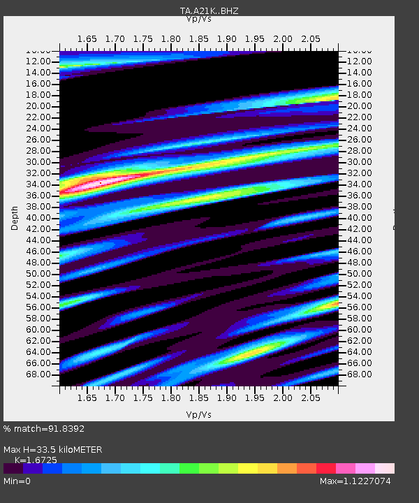
| Estimated Moho Depth: |
33.5 km |
| Estimated Crust Vp/Vs: |
1.67 |
| Assumed Crust Vp: |
6.048 km/s |
| Estimated Crust Vs: |
3.616 km/s |
| Estimated Crust Poisson's Ratio: |
0.22 |
|
| Radial Match: |
91.8392 % |
| Radial Bump: |
400 |
| Transverse Match: |
81.219604 % |
| Transverse Bump: |
400 |
| SOD ConfigId: |
7422571 |
| Insert Time: |
2019-04-19 13:55:44.726 +0000 |
| GWidth: |
2.5 |
| Max Bumps: |
400 |
| Tol: |
0.001 |
|
Signal To Noise
| Channel | StoN | STA | LTA |
| TA:A21K: :BHZ:20150701T19:47:32.525024Z | 3.2907505 | 8.997451E-7 | 2.734164E-7 |
| TA:A21K: :BHN:20150701T19:47:32.525024Z | 2.7484655 | 5.053251E-7 | 1.8385717E-7 |
| TA:A21K: :BHE:20150701T19:47:32.525024Z | 1.1428457 | 1.898826E-7 | 1.6614894E-7 |
| Arrivals |
| Ps | 3.8 SECOND |
| PpPs | 14 SECOND |
| PsPs/PpSs | 18 SECOND |


