You are here: Home > Network List > TA - USArray Transportable Network (new EarthScope stations) Stations List
> Station H21K Melozitna River, AK, USA > Earthquake Result Viewer
H21K Melozitna River, AK, USA - Earthquake Result Viewer
| Earthquake location: |
Solomon Islands |
| Earthquake latitude/longitude: |
-11.0/162.6 |
| Earthquake time(UTC): |
2015/07/01 (182) 19:35:21 GMT |
| Earthquake Depth: |
8.9 km |
| Earthquake Magnitude: |
5.8 MO |
| Earthquake Catalog/Contributor: |
NEIC PDE/NEIC ALERT |
|
| Network: |
TA USArray Transportable Network (new EarthScope stations) |
| Station: |
H21K Melozitna River, AK, USA |
| Lat/Lon: |
65.66 N/152.80 W |
| Elevation: |
520 m |
|
| Distance: |
83.3 deg |
| Az: |
17.051 deg |
| Baz: |
223.997 deg |
| Ray Param: |
0.04630961 |
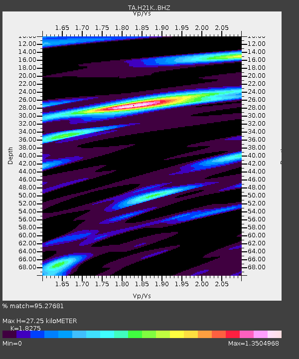
| Estimated Moho Depth: |
27.25 km |
| Estimated Crust Vp/Vs: |
1.83 |
| Assumed Crust Vp: |
6.566 km/s |
| Estimated Crust Vs: |
3.593 km/s |
| Estimated Crust Poisson's Ratio: |
0.29 |
|
| Radial Match: |
95.27681 % |
| Radial Bump: |
400 |
| Transverse Match: |
82.705635 % |
| Transverse Bump: |
400 |
| SOD ConfigId: |
7422571 |
| Insert Time: |
2019-04-19 13:55:54.226 +0000 |
| GWidth: |
2.5 |
| Max Bumps: |
400 |
| Tol: |
0.001 |
|

Signal To Noise
| Channel | StoN | STA | LTA |
| TA:H21K: :BHZ:20150701T19:47:16.099976Z | 11.427958 | 7.0207767E-7 | 6.1435095E-8 |
| TA:H21K: :BHN:20150701T19:47:16.099976Z | 5.3911595 | 1.7852234E-7 | 3.3113906E-8 |
| TA:H21K: :BHE:20150701T19:47:16.099976Z | 4.1091013 | 1.7694818E-7 | 4.30625E-8 |
| Arrivals |
| Ps | 3.5 SECOND |
| PpPs | 11 SECOND |
| PsPs/PpSs | 15 SECOND |


