You are here: Home > Network List > TA - USArray Transportable Network (new EarthScope stations) Stations List
> Station L19K White Mountain, AK, USA > Earthquake Result Viewer
L19K White Mountain, AK, USA - Earthquake Result Viewer
| Earthquake location: |
Solomon Islands |
| Earthquake latitude/longitude: |
-11.0/162.6 |
| Earthquake time(UTC): |
2015/07/01 (182) 19:35:21 GMT |
| Earthquake Depth: |
8.9 km |
| Earthquake Magnitude: |
5.8 MO |
| Earthquake Catalog/Contributor: |
NEIC PDE/NEIC ALERT |
|
| Network: |
TA USArray Transportable Network (new EarthScope stations) |
| Station: |
L19K White Mountain, AK, USA |
| Lat/Lon: |
62.18 N/154.85 W |
| Elevation: |
650 m |
|
| Distance: |
80.1 deg |
| Az: |
18.798 deg |
| Baz: |
222.41 deg |
| Ray Param: |
0.048504822 |
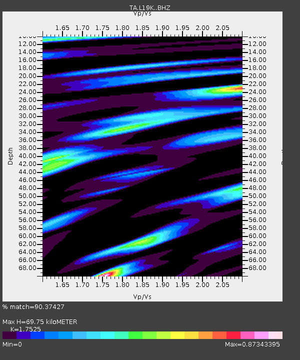
| Estimated Moho Depth: |
69.75 km |
| Estimated Crust Vp/Vs: |
1.75 |
| Assumed Crust Vp: |
6.438 km/s |
| Estimated Crust Vs: |
3.674 km/s |
| Estimated Crust Poisson's Ratio: |
0.26 |
|
| Radial Match: |
90.37427 % |
| Radial Bump: |
400 |
| Transverse Match: |
79.76494 % |
| Transverse Bump: |
400 |
| SOD ConfigId: |
7422571 |
| Insert Time: |
2019-04-19 13:56:05.065 +0000 |
| GWidth: |
2.5 |
| Max Bumps: |
400 |
| Tol: |
0.001 |
|
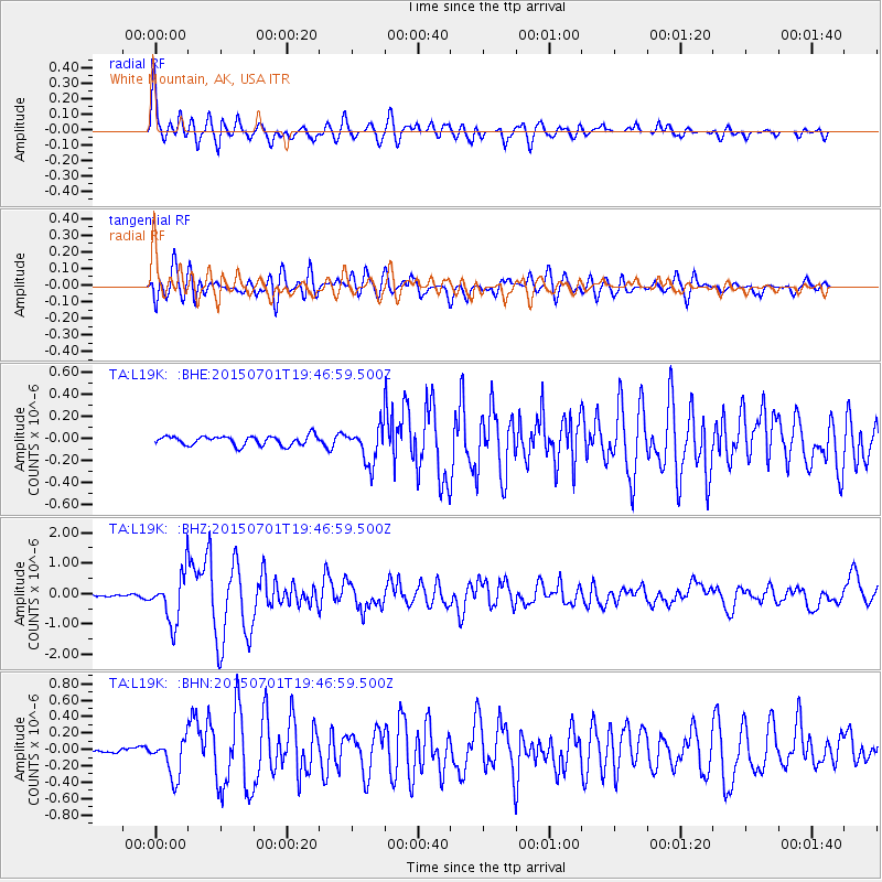
Signal To Noise
| Channel | StoN | STA | LTA |
| TA:L19K: :BHZ:20150701T19:46:59.500Z | 12.830682 | 8.0018987E-7 | 6.2365345E-8 |
| TA:L19K: :BHN:20150701T19:46:59.500Z | 4.790148 | 2.3055198E-7 | 4.8130456E-8 |
| TA:L19K: :BHE:20150701T19:46:59.500Z | 4.580258 | 1.9345636E-7 | 4.2237005E-8 |
| Arrivals |
| Ps | 8.4 SECOND |
| PpPs | 29 SECOND |
| PsPs/PpSs | 37 SECOND |


