You are here: Home > Network List > G - GEOSCOPE Stations List
> Station MPG Montagne des Peres, French Guyana > Earthquake Result Viewer
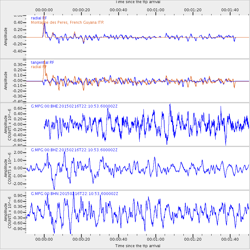
MPG Montagne des Peres, French Guyana - Earthquake Result Viewer
*The percent match for this event was below the threshold and hence no stack was calculated.
| Earthquake location: |
South Sandwich Islands Region |
| Earthquake latitude/longitude: |
-55.5/-28.2 |
| Earthquake time(UTC): |
2015/02/16 (047) 22:00:53 GMT |
| Earthquake Depth: |
10 km |
| Earthquake Magnitude: |
6.2 MWW, 6.7 MI |
| Earthquake Catalog/Contributor: |
NEIC PDE/NEIC COMCAT |
|
| Network: |
G GEOSCOPE |
| Station: |
MPG Montagne des Peres, French Guyana |
| Lat/Lon: |
5.11 N/52.64 W |
| Elevation: |
147 m |
|
| Distance: |
63.7 deg |
| Az: |
332.678 deg |
| Baz: |
164.811 deg |
| Ray Param: |
$rayparam |
*The percent match for this event was below the threshold and hence was not used in the summary stack. |
|
| Radial Match: |
68.626915 % |
| Radial Bump: |
400 |
| Transverse Match: |
63.400795 % |
| Transverse Bump: |
400 |
| SOD ConfigId: |
872571 |
| Insert Time: |
2015-03-02 22:04:46.772 +0000 |
| GWidth: |
2.5 |
| Max Bumps: |
400 |
| Tol: |
0.001 |
|
Signal To Noise
| Channel | StoN | STA | LTA |
| G:MPG:00:BHZ:20150216T22:10:53.600002Z | 2.2145565 | 8.795527E-7 | 3.971688E-7 |
| G:MPG:00:BHN:20150216T22:10:53.600002Z | 1.3715377 | 4.4094784E-7 | 3.2149887E-7 |
| G:MPG:00:BHE:20150216T22:10:53.600002Z | 1.8565973 | 3.4231348E-7 | 1.843768E-7 |
| Arrivals |
| Ps | |
| PpPs | |
| PsPs/PpSs | |


