You are here: Home > Network List > YN10 - San Jacinto Fault Zone Stations List
> Station JFS4 JFS4 > Earthquake Result Viewer
JFS4 JFS4 - Earthquake Result Viewer
| Earthquake location: |
Solomon Islands |
| Earthquake latitude/longitude: |
-11.0/162.6 |
| Earthquake time(UTC): |
2015/07/01 (182) 19:35:21 GMT |
| Earthquake Depth: |
8.9 km |
| Earthquake Magnitude: |
5.8 MO |
| Earthquake Catalog/Contributor: |
NEIC PDE/NEIC ALERT |
|
| Network: |
YN San Jacinto Fault Zone |
| Station: |
JFS4 JFS4 |
| Lat/Lon: |
33.42 N/116.40 W |
| Elevation: |
645 m |
|
| Distance: |
88.6 deg |
| Az: |
55.724 deg |
| Baz: |
255.969 deg |
| Ray Param: |
0.042453393 |
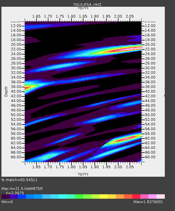
| Estimated Moho Depth: |
21.5 km |
| Estimated Crust Vp/Vs: |
2.07 |
| Assumed Crust Vp: |
6.264 km/s |
| Estimated Crust Vs: |
3.03 km/s |
| Estimated Crust Poisson's Ratio: |
0.35 |
|
| Radial Match: |
80.54511 % |
| Radial Bump: |
400 |
| Transverse Match: |
57.568905 % |
| Transverse Bump: |
400 |
| SOD ConfigId: |
7422571 |
| Insert Time: |
2019-04-19 13:58:53.076 +0000 |
| GWidth: |
2.5 |
| Max Bumps: |
400 |
| Tol: |
0.001 |
|

Signal To Noise
| Channel | StoN | STA | LTA |
| YN:JFS4: :HHZ:20150701T19:47:42.588989Z | 7.0548606 | 3.7233056E-7 | 5.2776457E-8 |
| YN:JFS4: :HHN:20150701T19:47:42.588989Z | 1.6538594 | 1.4158064E-7 | 8.560622E-8 |
| YN:JFS4: :HHE:20150701T19:47:42.588989Z | 1.6570421 | 1.5102404E-7 | 9.1140734E-8 |
| Arrivals |
| Ps | 3.7 SECOND |
| PpPs | 10 SECOND |
| PsPs/PpSs | 14 SECOND |


