You are here: Home > Network List > GT - Global Telemetered Seismograph Network (USAF/USGS) Stations List
> Station BOSA Boshof, South Africa > Earthquake Result Viewer
BOSA Boshof, South Africa - Earthquake Result Viewer
| Earthquake location: |
South Sandwich Islands Region |
| Earthquake latitude/longitude: |
-55.5/-28.2 |
| Earthquake time(UTC): |
2015/02/16 (047) 22:00:53 GMT |
| Earthquake Depth: |
10 km |
| Earthquake Magnitude: |
6.2 MWW, 6.7 MI |
| Earthquake Catalog/Contributor: |
NEIC PDE/NEIC COMCAT |
|
| Network: |
GT Global Telemetered Seismograph Network (USAF/USGS) |
| Station: |
BOSA Boshof, South Africa |
| Lat/Lon: |
28.61 S/25.26 E |
| Elevation: |
1280 m |
|
| Distance: |
46.4 deg |
| Az: |
77.296 deg |
| Baz: |
219.115 deg |
| Ray Param: |
0.070651636 |
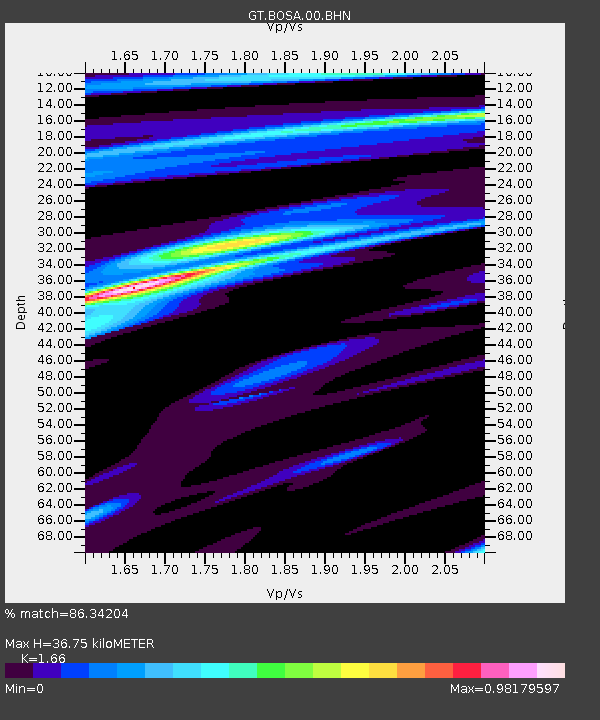
| Estimated Moho Depth: |
36.75 km |
| Estimated Crust Vp/Vs: |
1.66 |
| Assumed Crust Vp: |
6.459 km/s |
| Estimated Crust Vs: |
3.891 km/s |
| Estimated Crust Poisson's Ratio: |
0.22 |
|
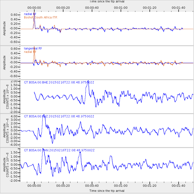
| Radial Match: |
86.34204 % |
| Radial Bump: |
328 |
| Transverse Match: |
70.14948 % |
| Transverse Bump: |
400 |
| SOD ConfigId: |
872571 |
| Insert Time: |
2015-03-02 22:05:04.457 +0000 |
| GWidth: |
2.5 |
| Max Bumps: |
400 |
| Tol: |
0.001 |
|
Signal To Noise
| Channel | StoN | STA | LTA |
| GT:BOSA:00:BHZ:20150216T22:08:48.975002Z | 3.1641963 | 1.3081968E-6 | 4.134373E-7 |
| GT:BOSA:00:BHN:20150216T22:08:48.975002Z | 2.4553862 | 7.0759137E-7 | 2.8817925E-7 |
| GT:BOSA:00:BHE:20150216T22:08:48.975002Z | 2.5410302 | 5.4729185E-7 | 2.1538189E-7 |
| Arrivals |
| Ps | 4.0 SECOND |
| PpPs | 14 SECOND |
| PsPs/PpSs | 18 SECOND |


