You are here: Home > Network List > WI - West Indies IPGP Network Stations List
> Station BIM Morne Bigot, Anses d'Arlets, Martinique > Earthquake Result Viewer
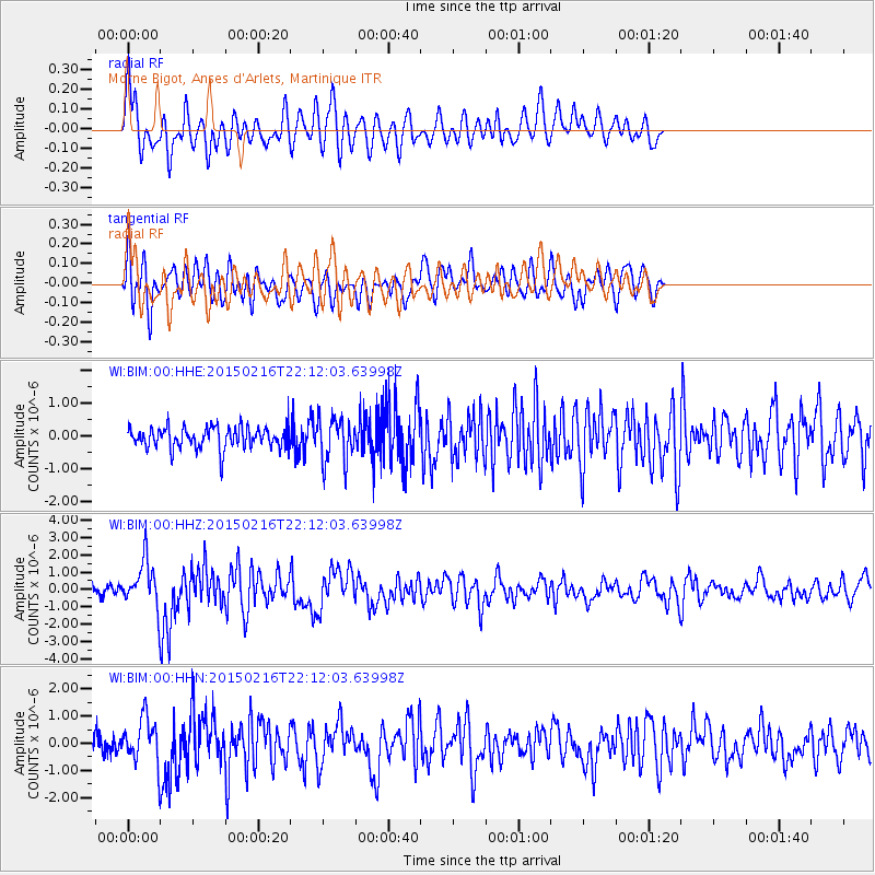
BIM Morne Bigot, Anses d'Arlets, Martinique - Earthquake Result Viewer
*The percent match for this event was below the threshold and hence no stack was calculated.
| Earthquake location: |
South Sandwich Islands Region |
| Earthquake latitude/longitude: |
-55.5/-28.2 |
| Earthquake time(UTC): |
2015/02/16 (047) 22:00:53 GMT |
| Earthquake Depth: |
10 km |
| Earthquake Magnitude: |
6.2 MWW, 6.7 MI |
| Earthquake Catalog/Contributor: |
NEIC PDE/NEIC COMCAT |
|
| Network: |
WI West Indies IPGP Network |
| Station: |
BIM Morne Bigot, Anses d'Arlets, Martinique |
| Lat/Lon: |
14.52 N/61.07 W |
| Elevation: |
391 m |
|
| Distance: |
75.1 deg |
| Az: |
327.09 deg |
| Baz: |
161.398 deg |
| Ray Param: |
$rayparam |
*The percent match for this event was below the threshold and hence was not used in the summary stack. |
|
| Radial Match: |
70.747444 % |
| Radial Bump: |
400 |
| Transverse Match: |
69.44098 % |
| Transverse Bump: |
400 |
| SOD ConfigId: |
872571 |
| Insert Time: |
2015-03-02 22:07:11.198 +0000 |
| GWidth: |
2.5 |
| Max Bumps: |
400 |
| Tol: |
0.001 |
|
Signal To Noise
| Channel | StoN | STA | LTA |
| WI:BIM:00:HHZ:20150216T22:12:03.63998Z | 3.6229556 | 1.2884042E-6 | 3.556224E-7 |
| WI:BIM:00:HHN:20150216T22:12:03.63998Z | 2.230094 | 7.957869E-7 | 3.5684005E-7 |
| WI:BIM:00:HHE:20150216T22:12:03.63998Z | 2.0075603 | 6.631498E-7 | 3.3032626E-7 |
| Arrivals |
| Ps | |
| PpPs | |
| PsPs/PpSs | |


