You are here: Home > Network List > WI - West Indies IPGP Network Stations List
> Station MAGL Barre de l'ile, Saint louis, Marie Galante > Earthquake Result Viewer
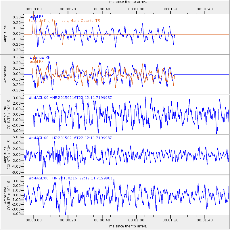
MAGL Barre de l'ile, Saint louis, Marie Galante - Earthquake Result Viewer
*The percent match for this event was below the threshold and hence no stack was calculated.
| Earthquake location: |
South Sandwich Islands Region |
| Earthquake latitude/longitude: |
-55.5/-28.2 |
| Earthquake time(UTC): |
2015/02/16 (047) 22:00:53 GMT |
| Earthquake Depth: |
10 km |
| Earthquake Magnitude: |
6.2 MWW, 6.7 MI |
| Earthquake Catalog/Contributor: |
NEIC PDE/NEIC COMCAT |
|
| Network: |
WI West Indies IPGP Network |
| Station: |
MAGL Barre de l'ile, Saint louis, Marie Galante |
| Lat/Lon: |
15.95 N/61.28 W |
| Elevation: |
150 m |
|
| Distance: |
76.5 deg |
| Az: |
327.354 deg |
| Baz: |
161.407 deg |
| Ray Param: |
$rayparam |
*The percent match for this event was below the threshold and hence was not used in the summary stack. |
|
| Radial Match: |
59.317616 % |
| Radial Bump: |
374 |
| Transverse Match: |
56.451164 % |
| Transverse Bump: |
312 |
| SOD ConfigId: |
872571 |
| Insert Time: |
2015-03-02 22:07:25.891 +0000 |
| GWidth: |
2.5 |
| Max Bumps: |
400 |
| Tol: |
0.001 |
|
Signal To Noise
| Channel | StoN | STA | LTA |
| WI:MAGL:00:HHZ:20150216T22:12:11.719998Z | 2.086709 | 1.9332965E-6 | 9.2648116E-7 |
| WI:MAGL:00:HHN:20150216T22:12:11.719998Z | 1.1858813 | 1.2039854E-6 | 1.0152664E-6 |
| WI:MAGL:00:HHE:20150216T22:12:11.719998Z | 1.4497019 | 1.6777504E-6 | 1.1573072E-6 |
| Arrivals |
| Ps | |
| PpPs | |
| PsPs/PpSs | |


