You are here: Home > Network List > TA - USArray Transportable Network (new EarthScope stations) Stations List
> Station G65A Princeton, ME, USA > Earthquake Result Viewer
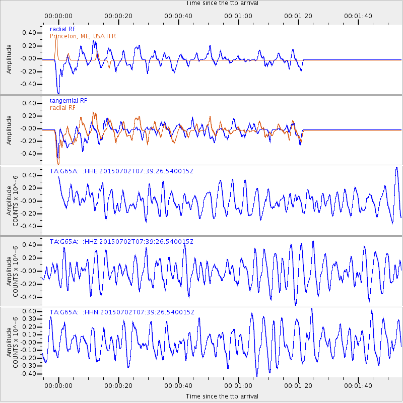
G65A Princeton, ME, USA - Earthquake Result Viewer
*The percent match for this event was below the threshold and hence no stack was calculated.
| Earthquake location: |
Southern Mid-Atlantic Ridge |
| Earthquake latitude/longitude: |
-34.7/-16.2 |
| Earthquake time(UTC): |
2015/07/02 (183) 07:26:49 GMT |
| Earthquake Depth: |
10 km |
| Earthquake Magnitude: |
5.7 MB |
| Earthquake Catalog/Contributor: |
NEIC PDE/NEIC ALERT |
|
| Network: |
TA USArray Transportable Network (new EarthScope stations) |
| Station: |
G65A Princeton, ME, USA |
| Lat/Lon: |
45.20 N/67.56 W |
| Elevation: |
78 m |
|
| Distance: |
92.1 deg |
| Az: |
326.442 deg |
| Baz: |
139.89 deg |
| Ray Param: |
$rayparam |
*The percent match for this event was below the threshold and hence was not used in the summary stack. |
|
| Radial Match: |
61.985397 % |
| Radial Bump: |
400 |
| Transverse Match: |
45.614 % |
| Transverse Bump: |
400 |
| SOD ConfigId: |
7422571 |
| Insert Time: |
2019-04-19 14:11:09.821 +0000 |
| GWidth: |
2.5 |
| Max Bumps: |
400 |
| Tol: |
0.001 |
|
Signal To Noise
| Channel | StoN | STA | LTA |
| TA:G65A: :HHZ:20150702T07:39:26.540015Z | 0.76273763 | 1.7910338E-7 | 2.3481651E-7 |
| TA:G65A: :HHN:20150702T07:39:26.540015Z | 0.74003714 | 1.3624525E-7 | 1.8410596E-7 |
| TA:G65A: :HHE:20150702T07:39:26.540015Z | 1.1900094 | 1.5242132E-7 | 1.2808412E-7 |
| Arrivals |
| Ps | |
| PpPs | |
| PsPs/PpSs | |


