You are here: Home > Network List > GS - US Geological Survey Networks Stations List
> Station KAN11 Stewart Ranch, Harper County, KS, USA > Earthquake Result Viewer
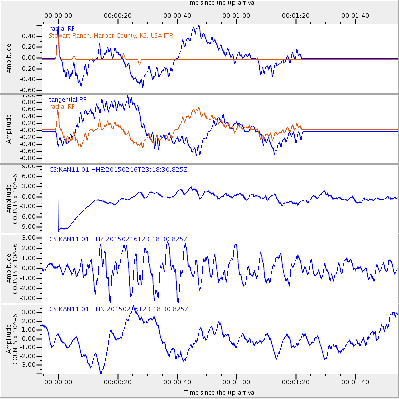
KAN11 Stewart Ranch, Harper County, KS, USA - Earthquake Result Viewer
*The percent match for this event was below the threshold and hence no stack was calculated.
| Earthquake location: |
Near East Coast Of Honshu, Japan |
| Earthquake latitude/longitude: |
39.8/142.9 |
| Earthquake time(UTC): |
2015/02/16 (047) 23:06:27 GMT |
| Earthquake Depth: |
23 km |
| Earthquake Magnitude: |
6.7 MWW, 6.9 MI |
| Earthquake Catalog/Contributor: |
NEIC PDE/NEIC COMCAT |
|
| Network: |
GS US Geological Survey Networks |
| Station: |
KAN11 Stewart Ranch, Harper County, KS, USA |
| Lat/Lon: |
37.21 N/97.91 W |
| Elevation: |
410 m |
|
| Distance: |
85.2 deg |
| Az: |
44.384 deg |
| Baz: |
317.575 deg |
| Ray Param: |
$rayparam |
*The percent match for this event was below the threshold and hence was not used in the summary stack. |
|
| Radial Match: |
39.660328 % |
| Radial Bump: |
400 |
| Transverse Match: |
33.993355 % |
| Transverse Bump: |
400 |
| SOD ConfigId: |
872571 |
| Insert Time: |
2015-03-02 23:13:04.802 +0000 |
| GWidth: |
2.5 |
| Max Bumps: |
400 |
| Tol: |
0.001 |
|
Signal To Noise
| Channel | StoN | STA | LTA |
| GS:KAN11:01:HHZ:20150216T23:18:30.825Z | 0.7818985 | 2.9835476E-7 | 3.8157734E-7 |
| GS:KAN11:01:HHN:20150216T23:18:30.825Z | 0.20364824 | 5.301442E-7 | 2.6032349E-6 |
| GS:KAN11:01:HHE:20150216T23:18:30.825Z | 1.4124811 | 4.523671E-6 | 3.202642E-6 |
| Arrivals |
| Ps | |
| PpPs | |
| PsPs/PpSs | |


