You are here: Home > Network List > IU - Global Seismograph Network (GSN - IRIS/USGS) Stations List
> Station JOHN Johnston Island, USA > Earthquake Result Viewer
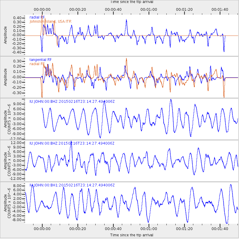
JOHN Johnston Island, USA - Earthquake Result Viewer
*The percent match for this event was below the threshold and hence no stack was calculated.
| Earthquake location: |
Near East Coast Of Honshu, Japan |
| Earthquake latitude/longitude: |
39.8/142.9 |
| Earthquake time(UTC): |
2015/02/16 (047) 23:06:27 GMT |
| Earthquake Depth: |
23 km |
| Earthquake Magnitude: |
6.7 MWW, 6.9 MI |
| Earthquake Catalog/Contributor: |
NEIC PDE/NEIC COMCAT |
|
| Network: |
IU Global Seismograph Network (GSN - IRIS/USGS) |
| Station: |
JOHN Johnston Island, USA |
| Lat/Lon: |
16.73 N/169.53 W |
| Elevation: |
2.0 m |
|
| Distance: |
47.1 deg |
| Az: |
105.186 deg |
| Baz: |
309.14 deg |
| Ray Param: |
$rayparam |
*The percent match for this event was below the threshold and hence was not used in the summary stack. |
|
| Radial Match: |
45.61029 % |
| Radial Bump: |
391 |
| Transverse Match: |
56.54953 % |
| Transverse Bump: |
294 |
| SOD ConfigId: |
872571 |
| Insert Time: |
2015-03-02 23:14:46.620 +0000 |
| GWidth: |
2.5 |
| Max Bumps: |
400 |
| Tol: |
0.001 |
|
Signal To Noise
| Channel | StoN | STA | LTA |
| IU:JOHN:00:BHZ:20150216T23:14:27.494006Z | 0.9515225 | 3.6020422E-6 | 3.7855561E-6 |
| IU:JOHN:00:BH1:20150216T23:14:27.494006Z | 0.34896627 | 1.7539313E-6 | 5.026077E-6 |
| IU:JOHN:00:BH2:20150216T23:14:27.494006Z | 1.8276172 | 7.0990213E-6 | 3.8843045E-6 |
| Arrivals |
| Ps | |
| PpPs | |
| PsPs/PpSs | |


