You are here: Home > Network List > UW - Pacific Northwest Regional Seismic Network Stations List
> Station LEBA Lebam, WA, USA > Earthquake Result Viewer
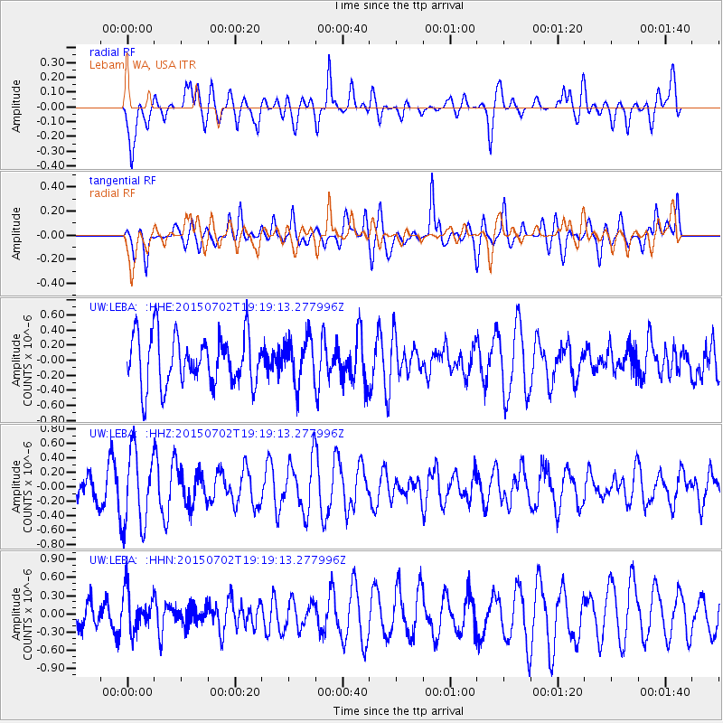
LEBA Lebam, WA, USA - Earthquake Result Viewer
*The percent match for this event was below the threshold and hence no stack was calculated.
| Earthquake location: |
South Of Kermadec Islands |
| Earthquake latitude/longitude: |
-32.1/-177.8 |
| Earthquake time(UTC): |
2015/07/02 (183) 19:06:36 GMT |
| Earthquake Depth: |
24 km |
| Earthquake Magnitude: |
5.2 MW |
| Earthquake Catalog/Contributor: |
ISC/ISC |
|
| Network: |
UW Pacific Northwest Regional Seismic Network |
| Station: |
LEBA Lebam, WA, USA |
| Lat/Lon: |
46.55 N/123.56 W |
| Elevation: |
73 m |
|
| Distance: |
92.3 deg |
| Az: |
34.112 deg |
| Baz: |
223.586 deg |
| Ray Param: |
$rayparam |
*The percent match for this event was below the threshold and hence was not used in the summary stack. |
|
| Radial Match: |
60.38712 % |
| Radial Bump: |
400 |
| Transverse Match: |
47.55767 % |
| Transverse Bump: |
400 |
| SOD ConfigId: |
7422571 |
| Insert Time: |
2019-04-19 14:21:19.686 +0000 |
| GWidth: |
2.5 |
| Max Bumps: |
400 |
| Tol: |
0.001 |
|
Signal To Noise
| Channel | StoN | STA | LTA |
| UW:LEBA: :HHZ:20150702T19:19:13.277996Z | 3.31671 | 5.158515E-7 | 1.555311E-7 |
| UW:LEBA: :HHN:20150702T19:19:13.277996Z | 1.3894554 | 3.268097E-7 | 2.3520704E-7 |
| UW:LEBA: :HHE:20150702T19:19:13.277996Z | 0.89702624 | 2.9974674E-7 | 3.3415606E-7 |
| Arrivals |
| Ps | |
| PpPs | |
| PsPs/PpSs | |


