You are here: Home > Network List > IU - Global Seismograph Network (GSN - IRIS/USGS) Stations List
> Station KIEV Kiev, Ukraine > Earthquake Result Viewer
KIEV Kiev, Ukraine - Earthquake Result Viewer

| Earthquake location: |
Northwest Of Kuril Islands |
| Earthquake latitude/longitude: |
47.8/146.2 |
| Earthquake time(UTC): |
2002/11/17 (321) 04:53:53 GMT |
| Earthquake Depth: |
459 km |
| Earthquake Magnitude: |
7.3 MW, 7.3 MW |
| Earthquake Catalog/Contributor: |
WHDF/NEIC |
|
| Network: |
IU Global Seismograph Network (GSN - IRIS/USGS) |
| Station: |
KIEV Kiev, Ukraine |
| Lat/Lon: |
50.69 N/29.21 E |
| Elevation: |
163 m |
|
| Distance: |
67.9 deg |
| Az: |
322.306 deg |
| Baz: |
40.38 deg |
| Ray Param: |
0.05509897 |
| Estimated Moho Depth: |
36.75 km |
| Estimated Crust Vp/Vs: |
1.83 |
| Assumed Crust Vp: |
6.552 km/s |
| Estimated Crust Vs: |
3.576 km/s |
| Estimated Crust Poisson's Ratio: |
0.29 |
|
| Radial Match: |
94.67489 % |
| Radial Bump: |
345 |
| Transverse Match: |
89.16511 % |
| Transverse Bump: |
400 |
| SOD ConfigId: |
4714 |
| Insert Time: |
2010-03-03 15:33:35.611 +0000 |
| GWidth: |
2.5 |
| Max Bumps: |
400 |
| Tol: |
0.001 |
|
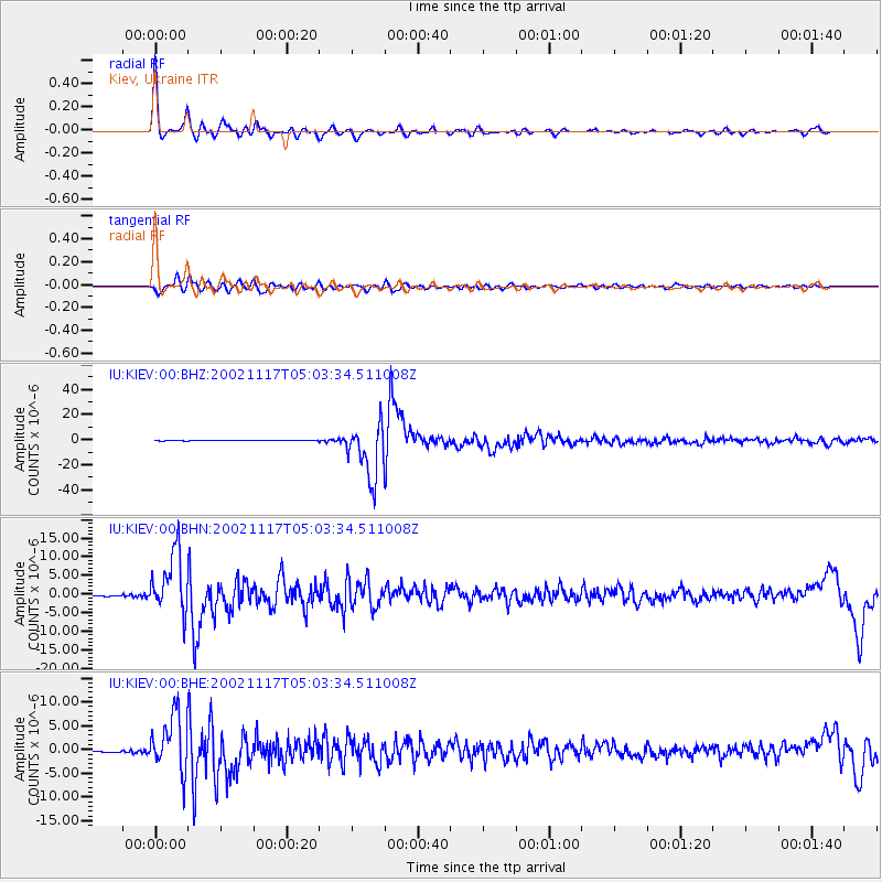
Signal To Noise
| Channel | StoN | STA | LTA |
| IU:KIEV:00:BHN:20021117T05:03:34.511008Z | 80.628296 | 8.143092E-6 | 1.00995464E-7 |
| IU:KIEV:00:BHE:20021117T05:03:34.511008Z | 70.63359 | 5.9553563E-6 | 8.431338E-8 |
| IU:KIEV:00:BHZ:20021117T05:03:34.511008Z | 99.47435 | 2.193515E-5 | 2.205106E-7 |
| Arrivals |
| Ps | 4.8 SECOND |
| PpPs | 15 SECOND |
| PsPs/PpSs | 20 SECOND |


