You are here: Home > Network List > CB - China National Seismic Network Stations List
> Station GZH Guangzhou,Guangdong Province > Earthquake Result Viewer
GZH Guangzhou,Guangdong Province - Earthquake Result Viewer
| Earthquake location: |
Southern Xinjiang, China |
| Earthquake latitude/longitude: |
37.5/78.1 |
| Earthquake time(UTC): |
2015/07/03 (184) 01:07:45 GMT |
| Earthquake Depth: |
10 km |
| Earthquake Magnitude: |
6.1 MB |
| Earthquake Catalog/Contributor: |
NEIC PDE/NEIC ALERT |
|
| Network: |
CB China National Seismic Network |
| Station: |
GZH Guangzhou,Guangdong Province |
| Lat/Lon: |
23.65 N/113.65 E |
| Elevation: |
65 m |
|
| Distance: |
33.3 deg |
| Az: |
104.189 deg |
| Baz: |
302.732 deg |
| Ray Param: |
0.07825593 |
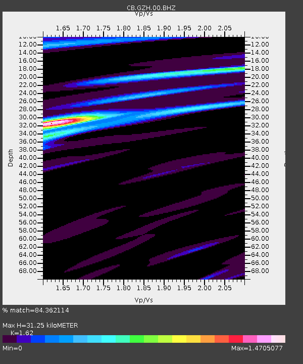
| Estimated Moho Depth: |
31.25 km |
| Estimated Crust Vp/Vs: |
1.62 |
| Assumed Crust Vp: |
6.276 km/s |
| Estimated Crust Vs: |
3.874 km/s |
| Estimated Crust Poisson's Ratio: |
0.19 |
|
| Radial Match: |
84.362114 % |
| Radial Bump: |
395 |
| Transverse Match: |
57.462006 % |
| Transverse Bump: |
400 |
| SOD ConfigId: |
7422571 |
| Insert Time: |
2019-04-19 14:28:52.415 +0000 |
| GWidth: |
2.5 |
| Max Bumps: |
400 |
| Tol: |
0.001 |
|

Signal To Noise
| Channel | StoN | STA | LTA |
| CB:GZH:00:BHZ:20150703T01:13:52.309985Z | 3.6619651 | 8.1151984E-7 | 2.2160775E-7 |
| CB:GZH:00:BHN:20150703T01:13:52.309985Z | 1.9802501 | 2.9313372E-7 | 1.4802863E-7 |
| CB:GZH:00:BHE:20150703T01:13:52.309985Z | 4.244091 | 4.838846E-7 | 1.14013716E-7 |
| Arrivals |
| Ps | 3.3 SECOND |
| PpPs | 12 SECOND |
| PsPs/PpSs | 15 SECOND |


